Article outline:
- Basic Terminology
- Source of a river
- Confluence
- Tributary
- Distributary
- Mouth of a river
- River basin, catchment area and watershed
- River Rejuvenation
- River Regime and River Discharge
- Drainage – Discordant and Concordant
- Discordant drainage
- Antecedent Drainage
- Superimposed Drainage
- Concordant Drainage
- Consequent Streams
- Subsequent Streams
- Obsequent Streams
- Resequent Streams
- Discordant drainage
- Drainage patterns
- Dendritic
- Trellis
- Rectangular
- Radial
- Annular
- Parallel
- Centripetal
- Deranged
- Barbed
- The Drainage System of India
- Classification of Drainage Systems in India
- On the basis of discharge of water – the Arabian Sea drainage, the Bay of Bengal drainage and inland drainage.
- On the basis of the size of the watershed – Major, Medium and minor
- On the basis of the mode of origin, nature and characteristics – the Himalayan drainage and the Peninsular drainage.
- The Himalayan drainage
- Evolution
- Major River systems
- The Peninsular drainage
- Evolution
- Major river systems
- Differences between the Himalayan and Peninsular river systems
- The shifting courses of rivers
- Classification of Drainage Systems in India
Before we study India’s Drainage system, it is imperative that we understand the basic terminology associated with a river and its drainage.
Some basic terms:
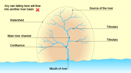
Source of a river: The beginning or start of a river.
Confluence: The point at which two rivers or streams join.
Distributary: The small river that branches out from the main river and then never meets again. It thus decreases the river’s water volume. Distributaries are commonly found on deltas but are also important in the formation of alluvial fans and cones.
Tributary: A stream or smaller river which joins a larger stream or river and thus increases its water volume.
Mouth: The point where the river comes to the end, usually when entering a sea.
Determination of left/right bank of a river: Stand facing the mouth of the river in the direction of its course. Your left hand side will be the left bank and your right hand side, the right bank.
River basin, catchment area and watershed
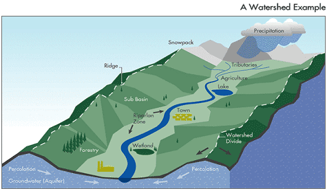
Generally, the area drained by a river and its tributaries is called its river basin or catchment area or a watershed. But, there are subtle differences between them.
River Basin: All the area drained by a river and its tributaries.
Catchment area: It refers to all the area of land over which rain falls and is caught to serve a river basin.
The catchment area of large rivers or river system is called a river basin while those of small rivers, a lake, a tank is often referred to as a watershed. Watersheds are small in area, generally less than 1000 ha.
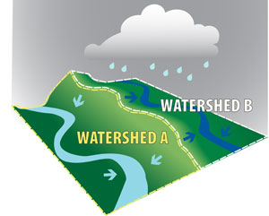
There are many smaller watersheds within a river basin. Example: watershed of Yamuna + water shed of Chambal + watershed of Gandak + …. = Drainage basin of Ganga.
Watershed:
Source
- As a catchment/drainage area: All the land with a common outlet for its surface water ie a geohydrological area from where the water drains to a common point.
Let’s watch this video for a better understanding:
- As a water divide: Watershed as a water divide refers to an elevated line from where the water flows in different directions into different river basins.
Source
The 3 major watersheds which direct and control the flow of surface water in India are:
- The Great Himalayan watershed with its important Karakoram branch
- In Central India, the watershed is formed by Vindhyas, Satpura and Maikala ranges.
- The Western Ghats.
A river basin or watershed is often taken as planning unit for macro/micro level developmental planning because:
- River basins and watersheds are marked by synergy and unity. What happens in one part of the basin or watershed (eg flood, drought etc.) directly affects the other parts and the unit as a whole.
- The data about land and water characteristics is measurable and comparable.
Base level of erosion and River Profile:
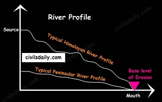
Base level of erosion: – It is the lowest level to which down-cutting by a river is possible, often referred to as the ‘mouth of the river’. The ultimate base level for any stream is the water body into which it flows – sea, lake, reservoir, dam etc. For large rivers, sea level is usually the base level, but a large river or lake is likewise the base level for tributary streams.
Under normal circumstances, the goal of a river is to do the work of erosion, initially up to its local and then permanent base level.
River Profile: It refers to the cross-section of a river from its source to mouth representing the height of the river at various points. The peninsular rivers have almost reached their base levels of erosion.
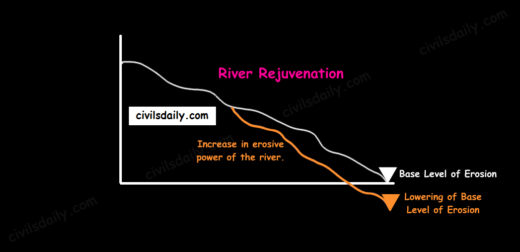
River Rejuvenation
River Rejuvenation refers to a significant enhancement in the erosive power of the rivers. It can happen because of the following reasons:
- Fall in the sea level (lowering of base level of erosion)
- Dynamic upliftment of the land
- For a given load, if there is a considerable increase in the volume of water.
- For a given volume of water, if there is a considerable decrease in the load.
River Regime and River Discharge:
Discharge: The volume of water flowing in a river measured over time. It is measured either in cusecs (cubic feet per second) or cumecs (cubic metres per second).
River regime: It refers to the seasonal fluctuation in respect of volume of water in the river.
Let’s consider the case of Himalayan and Peninsular rivers. The main differences in their flows are caused by the differences in climate. The main differences are:
- The regimes of Himalayan Rivers are monsoonal as well as glacial. This is because the Himalayan Rivers are perennial as they are fed by glaciers through snow melt and also receive rainfall water during rainy season. E.g. The river Ganga has its minimum flow during the January-June period, maximum flow is attained either in August or in September followed by a gradual steady fall afterwards.
- The regimes of most of the peninsular rivers, on the other hand, are monsoonal as they are fed by rainfall alone e.g. the river Narmada has a very low volume of discharge from Jan-July and a sharp rise in August (the rise corresponding with the monsoon season). The fall in October is as spectacular as the rise in August (as the monsoon season ends). It also varies from one part of the Peninsular plateau to the other.
