The Ganga River System
- The Ganga river system is the largest in India having a number of perennial and non-perennial rivers originating in the Himalayas in the north and the Peninsula in the south, respectively. It accounts for 26.3% of the geographical area of the country and is shared by ten states.
- Ambala is located on the water divide between Indus and Ganga.
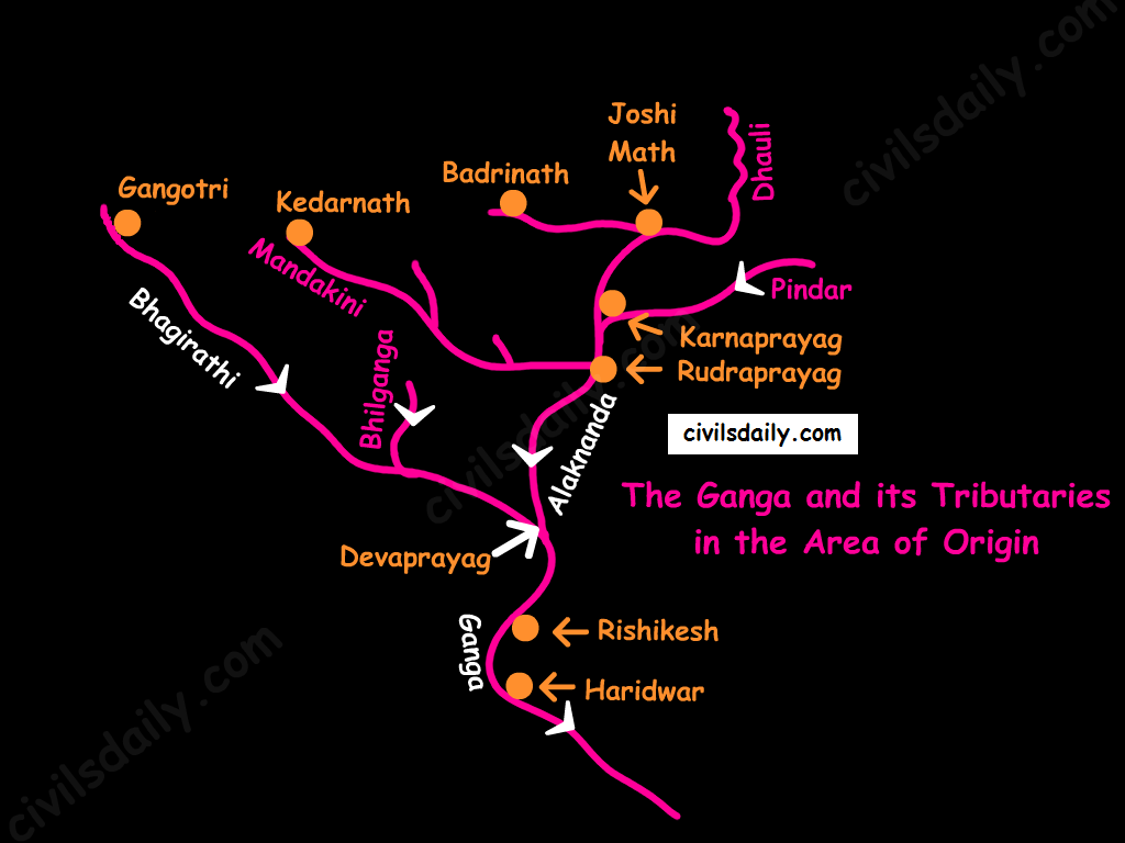
- Origin: It rises in the Gangotri glacier near Gaumukh in the Uttarkashi district of Uttaranchal. Here, it is known as the Bhagirathi. At Devprayag, the Bhagirathi meets the Alaknanda; hereafter, it is known as the Ganga.

- The river-course:
- The Ganga enters the plains at Haridwar.
- From here, it flows first to the south, then to the south-east direction to reach Allahabad. Here it is joined by the Yamuna.
- Further, near Rajmahal hills, Ganga turns south-east and bifurcates at Farakka into Bhagirathi – Hugli in West Bengal and as the Padma in Bangladesh.
- The river finally discharges itself into the Bay of Bengal near the Sagar Island.
Source
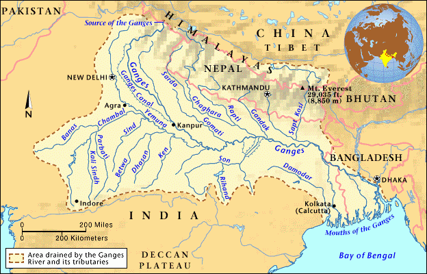
- Important left bank tributaries of the Ganga:
- Ramganga
- Gomati
- Ghaghara
- Gandak
- Kosi
- Mahananda
- Important right bank tributaries of the Ganga:
- Son
- Yamuna
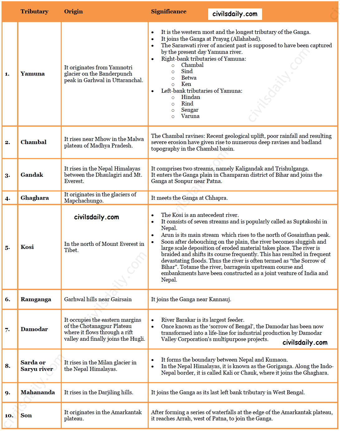
Some important tributaries and their characteristic features:

The Brahmaputra River System:
Source
- Origin: The Brahmaputra has its origin in the Chemayungdung glacier of the Kailash range near the Mansarovar lake. Mariam La separates the source of the Brahmaputra from the Manasarovar Lake.
- The river-course:
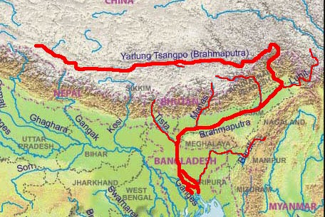
- Most of the course of the Brahmaputra lies in Tibet, popularly known as Tsangpo. It flows eastwards parallel to the Himalayas. It receives a large number of tributaries in Tibet. The first major tributary is the Raga Tsangpo meeting the Tsangpo near Lhatse Dzong.
- After reaching Namcha Barwa, it takes a “U” turn (also known as Hair Pin turn) and enters India west of Sadiya town in Arunachal Pradesh through the deep Dihang or Siang gorge of Himalayas. Here initially it is called as Siang and then as Dihang.
- It is joined by Dibang, Lohit, Kenula and many other tributaries and finally forms the Brahmaputra in Assam.
- It then enters into Bangladesh near Dhubri and flows southward. In Bangladesh, the Tista joins it on its right bank from where the river is known as the Jamuna. [Note: The Tista was a tributary of the Ganga prior to the floods of 1787 after which it diverted its course eastwards to join the Brahmaputra.]
- The Jamuna and Ganga confluence at Goalundo and afterwards are called as the Padma. Further south, Padma is joined by Meghna (Barak river in India) and thence onward it is known as Meghna to finally merge in the Bay of Bengal.
- It is called:
- The Tsangpo in Tibet ( Tsangpo = ‘the purifier.’)
- The Brahmaputra in India
- The Jamuna in Bangladesh
- Major left bank tributaries:
- Burhi Dihing,
- Dhansari (South)
- Kalang
- Major right bank tributaries:
- Subansiri ( It has its origin in Tibet and is an antecedent river.)
- Kameng
- Manas
- Sankosh
- Characteristic Features:
- River Brahmaputra is a little longer than the river Indus.
- It forms a spectacular Grand Canyon – like canyon in Tibet.
- The river is nearly 16 km wide at Dibrugarh and forms many islands, the most important of which is Majuli. Majuli is the world’s largest riverine island and India’s first island district.
- The Brahmaputra has a braided channel. It carries a lot of silt and there is excessive meandering.
- The Brahmaputra is well-known for floods, channel shifting and bank erosion. This is due to the fact that most of its tributaries are large, and bring large quantity of sediments owing to heavy rainfall in its catchment area.


Well explained