Temperature Conditions during this season:
As the sun shifts northwards, the temperature rapidly increases especially in the northern India.
The wind circulation over the subcontinent undergoes a complete reversal at both, the lower as well as the upper levels. Let’s see how:
Distribution of air pressure and winds on the surface of the earth:
- As a result of rapid increase in temperature in May over the north-western plains, the low-pressure conditions over there get further intensified.
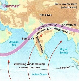
- Because of the heating of the subcontinent, by the middle of July, the low-pressure belt near the surface [termed as Inter Tropical Convergence Zone (ITCZ)] shifts northwards, roughly parallel to the Himalayas between 20° N and 25° N. The ITCZ in this position is sometimes called the monsoon trough.
[Revision Note: ITCZ is the low-pressure zone located at the equator where the trade winds converge. It is also referred to as the thermal equator. It is a zone of generally calm, hot, rising air and low pressure.]
- Roughly, this elongated low-pressure monsoon trough extends over the Thar desert in the north-west to Patna and Chotanagpur plateau in the east-southeast.
- Meanwhile, the sea surrounding India heats up slowly, creating a zone of relatively high pressure off India’s Southern Coastline.
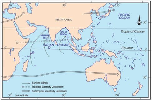
- Next, because winds blow from high to low pressure, warm moisture-laden air moves south-westerly direction from the sea over to India in the north and North East and is deflected by the Coriolis force as the Earth spins. It is this moist air current which is popularly known as the south-west monsoon.
Image Source
Jet Stream and Upper Air Circulation:
- By this time, the westerly jet stream withdraws from the Indian region. In fact, meteorologists have found an interrelationship between the northward shift of the equatorial trough (ITCZ) and the withdrawal of the westerly jet stream from over the North Indian Plain. It is generally believed that there is a cause and effect relationship between the two.
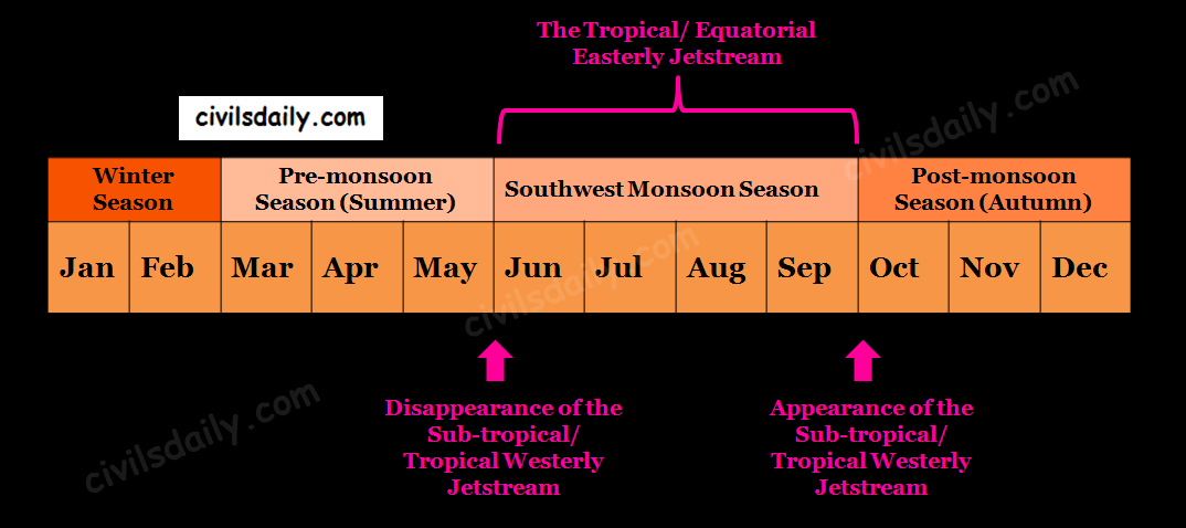
- An easterly jet stream flows over the southern part of the Peninsula in June and has a maximum speed of 90 km per hour. In August, it is confined to 15°N latitude, and in September up to 22° N latitudes. The easterlies normally do not extend to the north of 30° N latitude in the upper atmosphere.
Easterly Jet Stream and Tropical Cyclones: [The tropical cyclones were discussed in detail in the discussion on summer season. Remember? Revise here before moving forward!]
- The easterly jet stream steers the tropical depressions into India.
- These depressions play a significant role in the distribution of monsoon rainfall over the Indian subcontinent. The tracks of these depressions are the areas of highest rainfall in India.
- The frequency at which these depressions visit India, their direction and intensity, all go a long way in determining the rainfall pattern during the south-west monsoon period.
The onset and progress of South-West Monsoon in India:
1. Entry of Monsoon into India:
- The rain in the south-west monsoon season begins rather abruptly. This sudden onset of the moisture-laden winds associated with violent thunder and lightning is often termed as the “break” or “burst” of the monsoons.
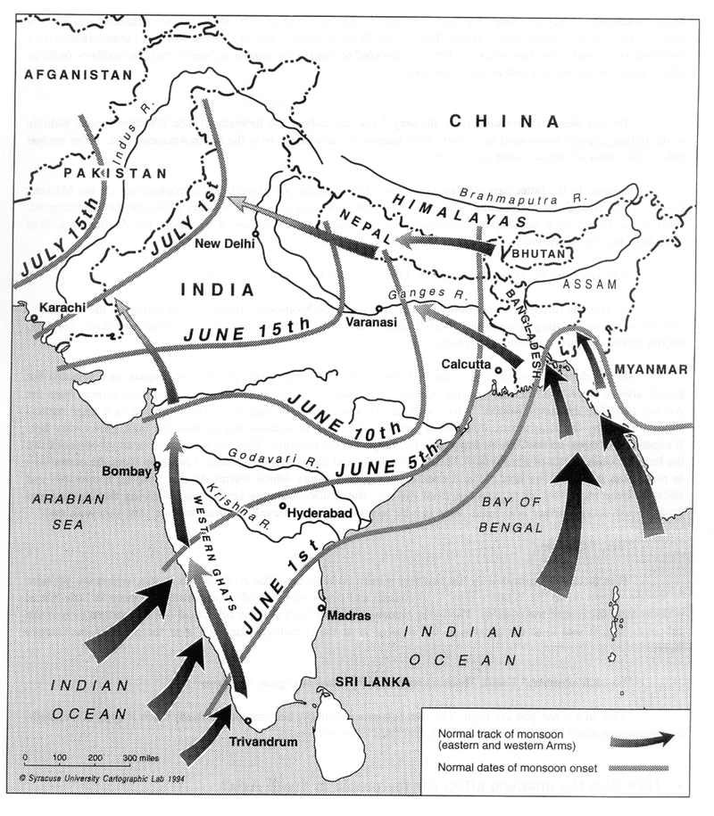
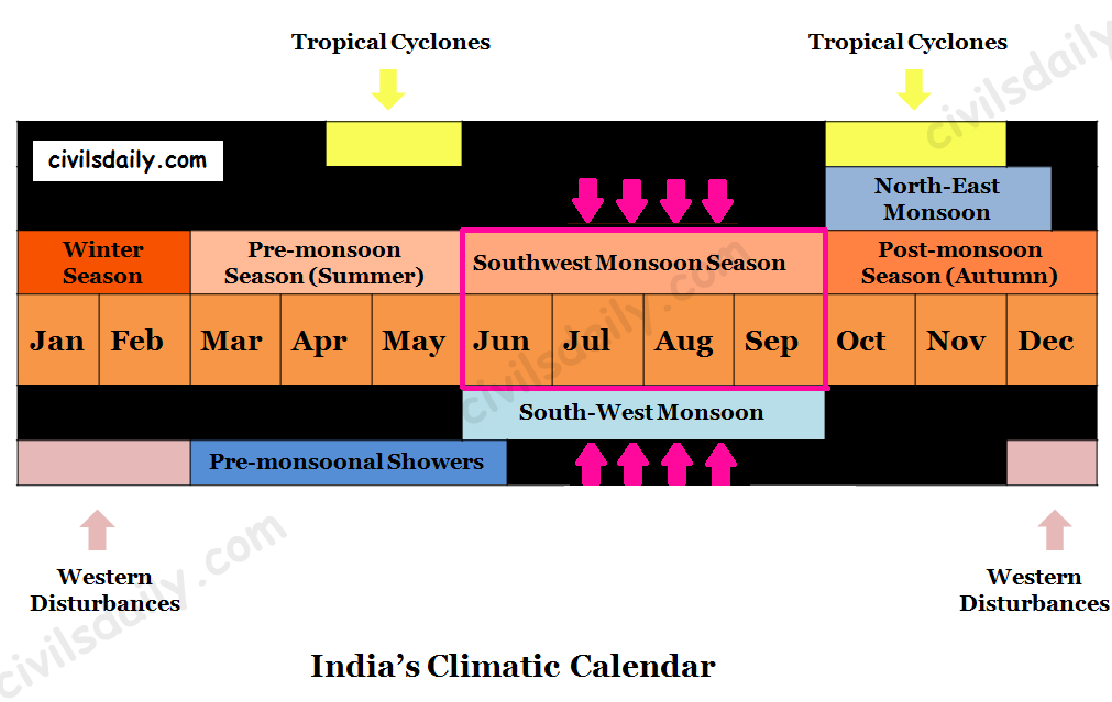
- The mean date for the burst of monsoon along the coast of Kerala is 1 first June with a coefficient of variation of a week. It reaches the interior parts of the country by the first week of July. By mid-July, south-west monsoon engulfs the entire subcontinent.
Image Source
- Impact of this rainfall: One result of the first rain is that it brings down the temperature substantially. The day temperature registers a decline of 5°C to 8°C between mid-June and mid-July.
2. The progress of monsoons: As these winds approach the land, their south-westerly direction is modified by:
- The relief, and
- The thermal low pressure over the north-west India.
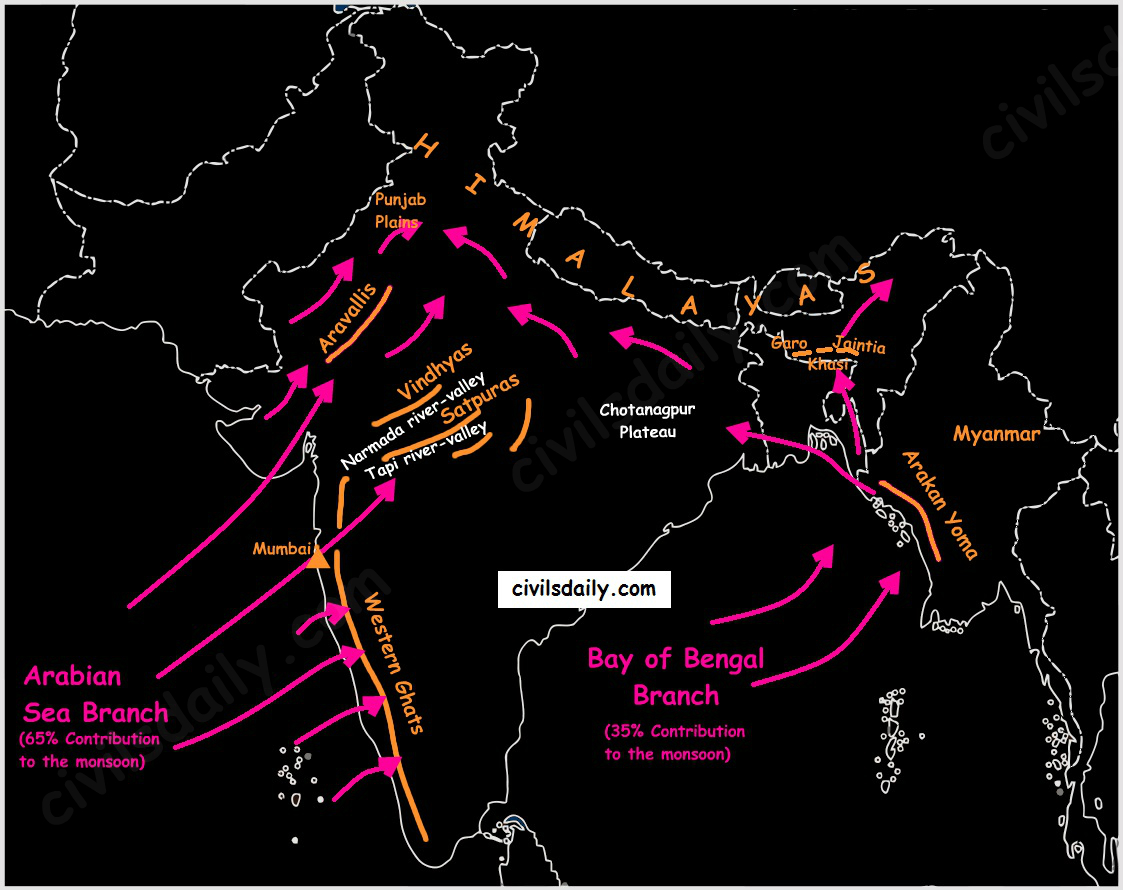
The monsoon approaches the landmass in two branches:
- The Arabian Sea branch
- The Bay of Bengal branch.
The Arabian Sea branch:
The monsoon winds originating over the Arabian Sea further split into three branches:
- One branch is obstructed by the Western Ghats.
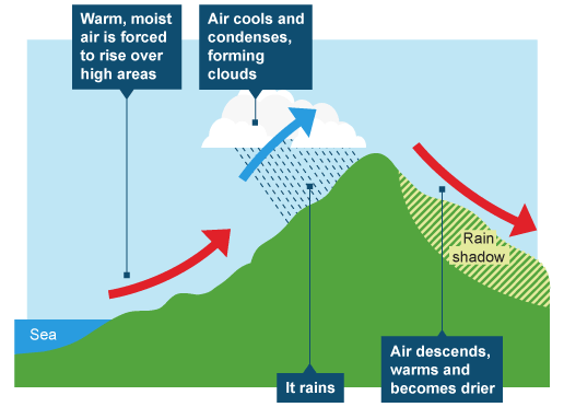
- As these winds climb the slopes of the Western Ghats, they become cooler, their moisture retention capacity reduces and as a result, the windward side of the Sahyadris and Western Coastal Plain receive very heavy rainfall ranging between 250 cm and 400 cm.
- Much of the rainfall along the Western Ghats is thus orographic, as the moist air is obstructed and forced to rise along the Ghats.
- After crossing the Western Ghats, these winds descend and get heated up. This reduces humidity in the winds. As a result, these winds cause little rainfall east of the Western Ghats. This region of low rainfall is known as the rain-shadow area.
Image Source
- Another branch of the Arabian Sea monsoon strikes the coast north of Mumbai. Moving along the Narmada and Tapi river valleys, these winds cause rainfall in extensive areas of central India. The Chotanagpur plateau gets 15 cm rainfall from this part of the branch. Thereafter, they enter the Ganga plains and mingle with the Bay of Bengal branch.
- The third branch of this monsoon wind strikes the Saurashtra Peninsula and the Kachchh. It then passes over west Rajasthan and along the Aravallis, causing only a scanty rainfall. In Punjab and Haryana, it too joins the Bay of Bengal branch. These two branches, reinforced by each other, cause rains in the western Himalayas.
Note: Though this branch passes through Rajasthan, it does not cause rainfall there. This is because:
- The direction of Aravallis is parallel to these monsoon winds.
- The dry and hot winds from the Sindh region of Pakistan lessen the relative humidity of these monsoon winds and do not allow them to get saturated.
The Bay of Bengal branch:
- The Bay of Bengal branch strikes the coast of Myanmar and parts of south-east Bangladesh. But the Arakan Hills along the coast of Myanmar deflect a big portion of this branch towards the Indian subcontinent.
- The monsoon, therefore, enters West Bengal and Bangladesh from the south and south-east instead of from the south-westerly direction.
- From here, this branch splits into two under the influence of the Himalayas and the thermal low in north-west India.
- One branch moves westward along the Ganga plains reaching as far as the Punjab plains.
- The other branch moves up the Brahmaputra valley in the north and the northeast, causing widespread rains.
- Its sub-branch strikes the Garo and Khasi hills of Meghalaya. The hills of Garo, Khasi and Jaintia are expanded in a funnel shape with an opening towards the sea. So the moist winds coming from the Bay of Bengal undergo a sudden rise here and cause excessive rainfall. Mawsynram, located on the crest of Khasi hills, receives the highest average annual rainfall in the world (1141cm).
- There is relatively less rainfall on the leeward slope of the Meghalaya Plateau e.g. 143 cm in Shillong and 161 cm in Guwahati which is very less in comparison to that in Mawsynram.
- The Brahmaputra valley to the north also experiences a rain-shadow effect; the problem is mitigated, however, by the adjacent Himalayas, which cause the winds to rise again, thereby establishing a parallel belt of heavy precipitation.
Note:
- The Arabian Sea branch is stronger than the Bay of Bengal branch. 65% of the humidity brought by the monsoon comes from the Arabian Sea whereas the monsoon coming from the Bay of Bengal contributes only 35% to the humidity.
- In the Gangetic Plains, the two branches merge into one. By the time they reach the Punjab their moisture is largely spent. The gradual reduction in the amount of rainfall toward the west is evidenced by the decline from 162 cm at Kolkata to 66 cm at Delhi and to desert conditions still farther west.
- Over the north-eastern portion of peninsular India, the two branches also intermittently collide, creating weak weather fronts with sufficient rainfall to produce patches of fairly high precipitation (more than 152 cm) in the Chotanagpur plateau.
Here it is important to know why the Tamil Nadu coast remains dry during this season.
It is because:
- The Tamil Nadu coast is situated parallel to the Bay of Bengal branch of south-west monsoon.
- It lies in the rain-shadow area of the Arabian Sea branch of the south-west monsoon.
3. Break in the Monsoon
During the south-west monsoon period after having rains for a few days, if rain fails to occur for one or more weeks, it is known as ‘break’ in the monsoon. These dry spells are quite common during the rainy season.
Reasons:
- These breaks in rainfall are related to the cyclonic depressions mainly formed at the head of the Bay of Bengal, and their crossing into the mainland. Besides the frequency and intensity of these depressions, the passage followed by them determines the spatial distribution of rainfall.
- In northern India rains are likely to fail if the rain-bearing storms are not very frequent along the monsoon trough or the ITCZ over this region.
- Over the west coast, the dry spells are associated with days when winds blow parallel to the coast.
4. The Withdrawal of the SW monsoon:
The withdrawal of the SW monsoon and the onset of the NE monsoon in the end of September are a gradual phenomenon. They take place almost at the same time and tend to merge. This explains the popularity of the phrase “Retreating Monsoon”. This will be taken up in detail in the discussion on Autumn Season.
