From UPSC perspective, the following things are important :
Prelims level: Nicobar Triangle, GNI Project
Why in the News?
- The opposition party has demanded the immediate suspension of all clearances granted to NITI Aayog’s Great Nicobar Island (GNI) Project.
- It alleged violations of due process, legal and constitutional provisions protecting tribal communities.

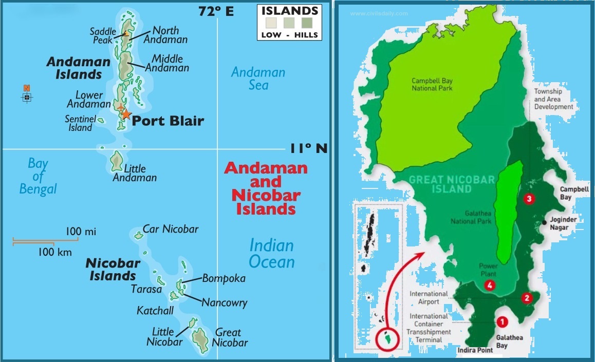
Great Nicobar Island: An Overview
|
What is GNI Project?
The GNI Project refers to the “Holistic Development of Great Nicobar Island,” a proposed mega project being piloted by NITI Aayog.
- Implementing Agency: The project is to be implemented by the Andaman and Nicobar Islands Integrated Development Corporation (ANIIDCO).
- Historical Context: Development plans for a port in Great Nicobar date back to the 1970s, aimed at leveraging its strategic location near the Malacca Strait.
- The project aims to develop the southern end of the Andaman and Nicobar group of Islands in the Bay of Bengal by constructing –
- Transshipment port
- Dual-use military-civil international airport
- Power plant (450 MVA gas and solar-based) and
- A township over a span of 30 years on more than 160 sq. km of land, of which 130 sq. km is primary forest
Features of the Project
- Transshipment hub of the East: The proposed port will allow Great Nicobar to participate in the regional and global maritime economy by becoming a major player in cargo transshipment.
- Naval control: The port will be controlled by the Indian Navy, while the airport will have dual military-civilian functions and will cater to tourism as well.
- Urban amenities: Roads, public transport, water supply and waste management facilities, and several hotels have been planned to cater to tourists.
Significance of the project
- Economic significance: The proposed port would allow GNI to become a significant player in cargo transhipment, as it is positioned equidistant from Colombo, Port Klang (Malaysia), and Singapore.
- Strategic significance: The proposal to develop GNI has been on the table since the 1970s, and it has been highlighted repeatedly as a crucial element for national security and consolidation of the Indian Ocean Region.
- In recent years, the escalating Chinese presence in the Indian Ocean has added greater urgency to this imperative.
Issues with the Project
- The project entails the deforestation of 130 sq km, and felling 10 lakh trees, threatens biodiversity at Galathea Bay, displaces indigenous tribes, lacks thorough impact assessments, and poses seismic risks to vulnerable communities.
Due-process Violations highlighted by the ‘Opposition’
(1) Did not recognise the grant ownership: The island administration did not recognise or grant ownership of any forest land to local tribespeople as per FRA, a requisite step under the Forest Conservation Rules, 2017, before Stage-I clearance is granted.
- This is despite the fact that Rule 6(3)(e) of Forest Conservation Rules-2017 (FCR) requires that any diversion of forest land first requires the District Collector to recognise and vest rights to locals under the FRA.
- The legislation allows forest communities the right to control and manage the use of the forest land over which they hold titles, and their consent is mandatory for diverting it.
(2) Inconsistencies with Stage-I Clearance: The Stage-I clearance for the project was granted in October 2022, two years after the application was received. Monthly progress reports show that the district administration did not process any claims over forest land under the FRA in the 26 months since project sanction.
(3) Withdrawal of Consent: Weeks after the Stage-I clearance was granted, the Tribal Council at Campbell Bay withdrew the consent granted by the Gram Sabha.
Get an IAS/IPS ranker as your 1: 1 personal mentor for UPSC 2024
