Prelims Spotlight is a part of “Nikaalo Prelims 2020” module. This open crash course for Prelims 2020 has a private telegram group where PDFs and DDS (Daily Doubt Sessions) are being held. Please click here to register.
The Northern and Northeastern Mountains with Important Passes
08 May 2020
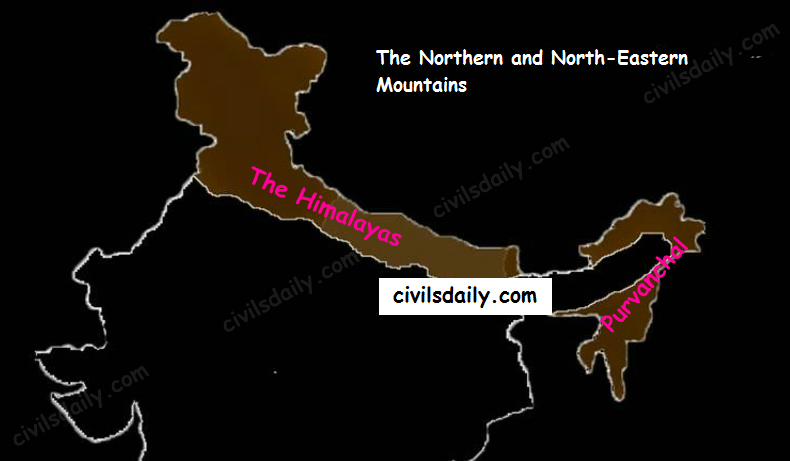
Let’s begin with the first physiographic division. It consists of:
- The Himalayas, and
- The Northeastern hills (Purvanchal).
A) The Himalayas:
The name “Himalaya” means “the abode or house of snow” in Sanskrit (i.e. hima “snow”, and ālaya “abode or house”). The Himalayas are the highest and longest of all young fold mountains of the world. The Pamir, known as the roof of the world, connects the Himalayas with the high ranges of Central Asia.
Let’s begin by understanding how the Himalayas came into being:
Origin and development:
According to the theory of Continental Drift, the world was made up of a single continent through most of the geologic time. That continent eventually separated and drifted apart; forming the seven continents we have today.
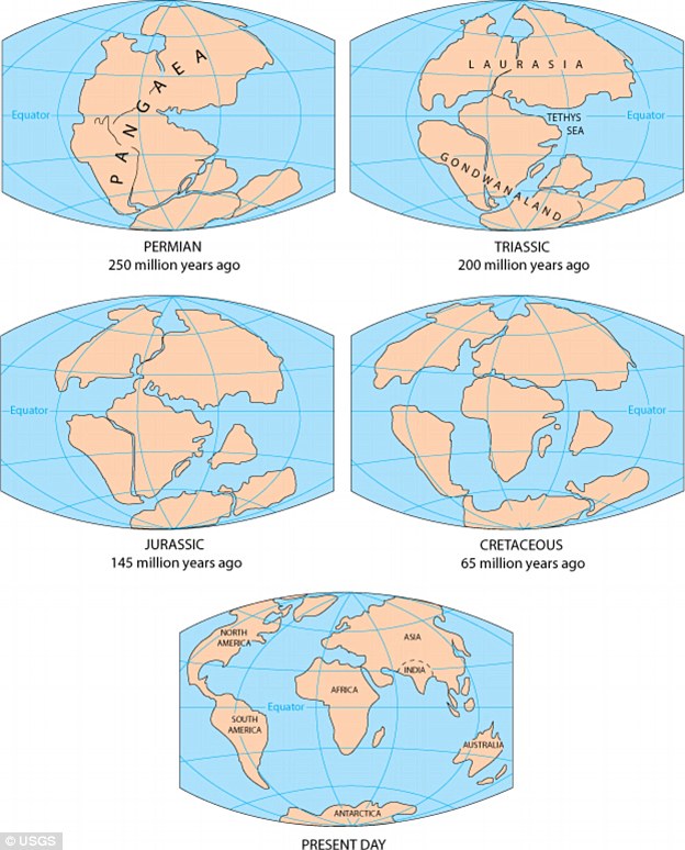
About 200 million years ago: Pangaea broke apart leading to the formation of two landmasses – “Laurasia in North” and “Gondwanaland in South”. Both the landmasses were separated by a shallow sea called “Tethys Sea”. The size of Tethys sea kept on decreasing due to movement of landmasses towards each other
About 40 to 50 million years ago: The two large landmasses, India and Eurasia, driven by plate movement, collided. As a result, the sediments accumulated in Tethys Sea (brought by rivers) were compressed, squeezed and series of folds were formed, one behind the other, giving birth to folded mountains of the Himalayas.
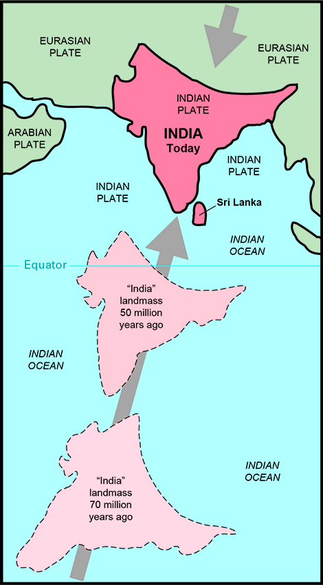
Recent studies show that India is still moving northwards at the rate of 5cm/year and crashing into the rest of Asia, thereby constantly increasing the height of Himalayas.
Evidence to prove that the Himalayas are still rising:
1. Fossil formation found in Shivalik hills:
Similar fossils have also been found in the Tibet Plateau. This indicates that in the past, Tibetan plateau and Shivalik hills shared a common location, similar level and thus similar vegetation, life etc.; then Tibetan plateau got uplifted.
2. Desiccation of lakes of Tibet:
In the Tibet plateau, we find deposits which are generally found in lakes. This indicates that lakes once existed in Tibet but because of upliftment the water got discharged and deposits remained.
3. Frequent Earthquakes
4. Youthful nature of rivers (High erosion, v-shaped valleys etc.)
The North-South Division of the Himalayas
The Himalayas consist of a series of parallel mountain ranges:
- The Greater Himalayan range, which includes:
- The Great Himalayas(Himadri), and
- The Trans-Himalayan range
- The Lesser Himalayas (or Himachal), and
- The Outer Himalayas (or Shiwalik).
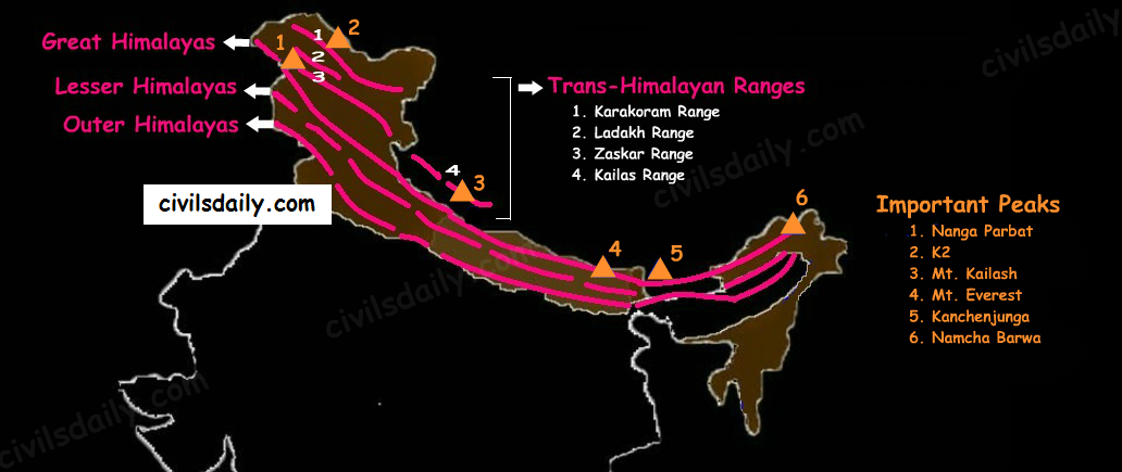
- Formation of these ranges: The Himadri and Himachal ranges of the Himalayas have been formed much before the formation of Siwalik range. The rivers rising in the Himadri and Himachal ranges brought gravel, sand and mud along with them, which was deposited in the rapidly shrinking Tethys Sea. In course of time, the earth movements caused folding of these relatively fresh deposits of sediments, giving rise to the least consolidated Shiwalik range.
- Characteristic Features:
- Notice in the map shown above that the Himalayas form an arcuate curve which is convex to the south. This curved shape of the Himalayas is attributed to the maximum push offered at the two ends on the Indian peninsula during its northward drift. In the north-west, it was done by Aravalis and in the Northeast by the Assam ranges.
- Syntaxis/ Syntaxial bends: The gently arching ranges of the Himalayan mountains on their Western and Eastern extremities are sharply bent southward in deep Knee-bend flexures that are called syntaxial bends. On both the ends, the great mountains appear to bend around a pivotal point. The western point is situated south of the Pamir where the Karakoram meets the Hindu Kush. A similar sharp, almost hairpin bend occurs on the eastern limit of Arunachal Pradesh where the strike of the mountain changes sharply from the Easterly to Southerly trend. Besides these two major bends, there are a number of minor syntaxial bends in other parts of Himalayas.
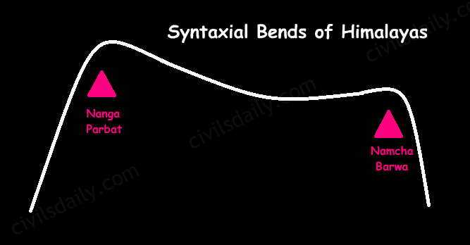
Syntaxial Bends of Himalayas
- The Himalayas are wider in the west than in the east. The width varies from 400 km in Kashmir to 150 km in Arunachal Pradesh.The main reason behind this difference is that the compressive force was more in the east than in the west. That is why high mountain peaks like Mount Everest and Kanchenjunga are present in the Eastern Himalayas.
- The ranges are separated by deep valleys creating a highly dissected topography.
- The southern slopes of the Himalayas facing India are steeper and those facing the Tibetan side are generally gentler.
- Let’s take up these Himalayan mountain ranges one by one:
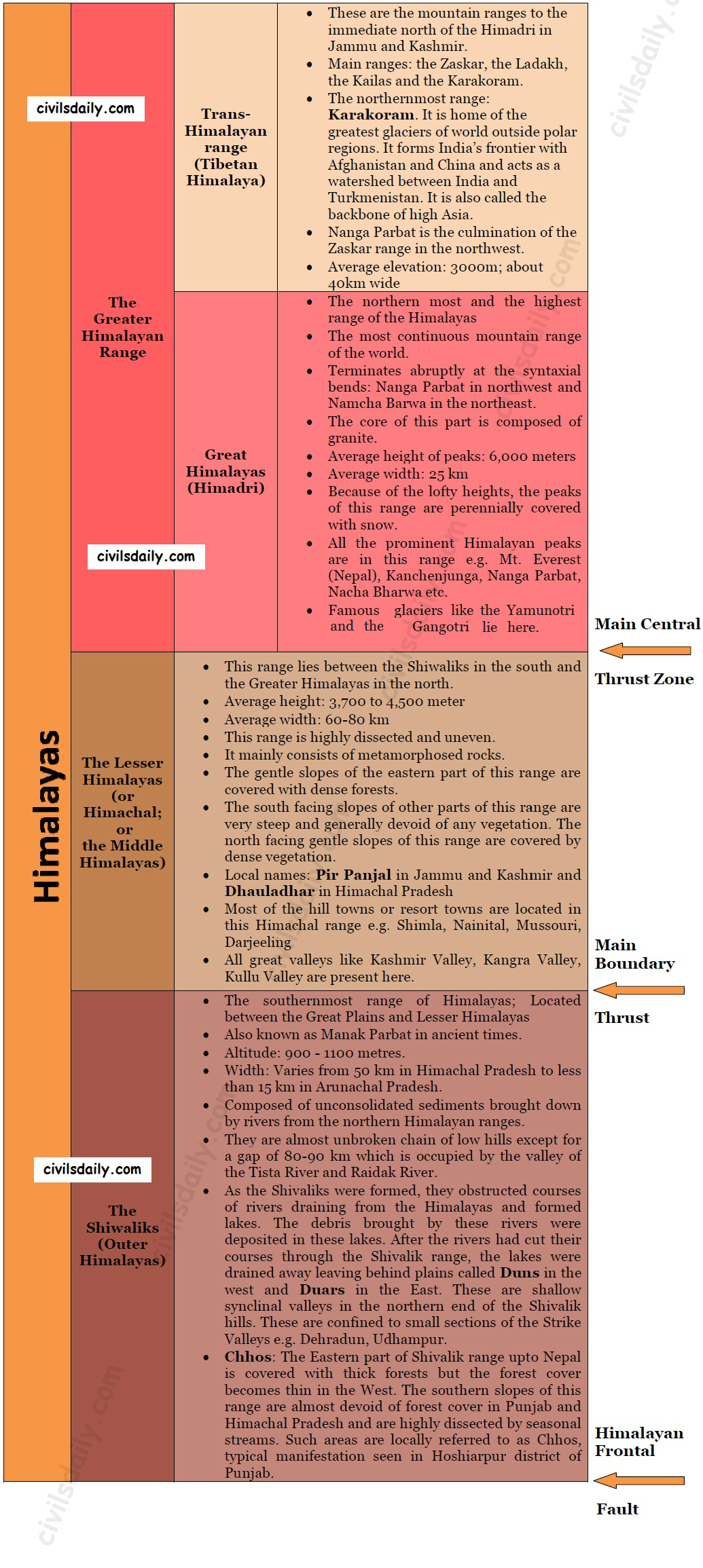
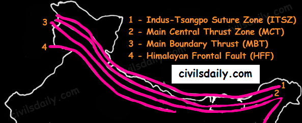
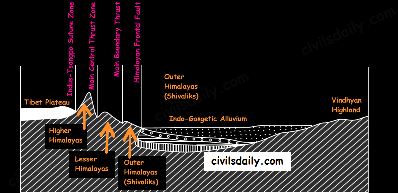
The Himalayan Ranges | the Greater Himalayan Range, the Lesser Himalayas, the Shivaliks Indus-Tsangpo Suture Zone: It represents a belt of tectonic compression caused by the underthrusting of the Indian shield/ plate against the Tibetan mass. It marks the boundary between Indian and Eurasian plates. The suture zone stretches from the North Western Himalayan syntaxis bordering the Nanga Parbat to the East as far as the Namche Barwa Mountain. Tha Karakoram range and the Ladakh plateau lie to the north of ITSZ and originally formed a part of the European plate.Main Central Thrust Zone: This separates the Higher Himalayas in the north from lesser Himalayas in the south. It has played an important role in the tectonic history of these mountains.Main Boundary Thrust: It is a reverse fault of great dimensions which extends all the way from Assam to Punjab and serves to separate the outer Himalayas from the lesser Himalayas.Himalayan Frontal Fault: It is a series of reverse faults that demarcates the boundary of the Shivalik from of the Himalayan province from the alluvial expanse of the Indo-Gangetic plains.
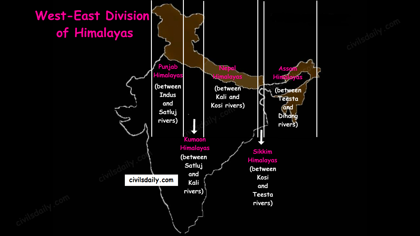
Besides the longitudinal divisions, the Himalayas have been divided on the basis of regions from west to east:
These divisions have been demarcated by river valleys:
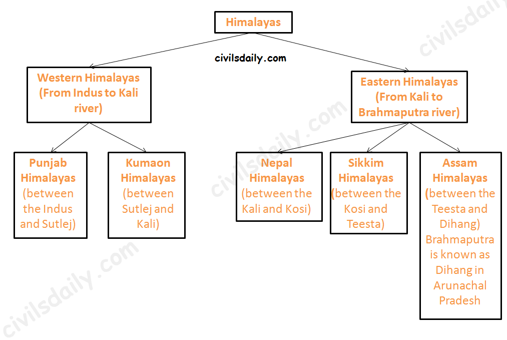
- Punjab Himalayas:
- A large portion of Punjab Himalayas is in Jammu and Kashmir and Himachal Pradesh. Hence they are also called the Kashmir and Himachal Himalaya.
- Major ranges: Karakoram, Ladakh, Pir Panjal, Zaskar and Dhaola Dhar.
- The general elevation falls westwards.
- The Kashmir Himalayas are also famous for Karewa formations.
- ‘Karewas’ in Kashmiri language refer to the lake deposits, found in the flat-topped terraces of the Kashmir valley and on the flanks of the Pir Panjal range.
- These deposits consist of clays, silts and sands, these deposits also show evidence of glaciation.
- The occurrence of tilted beds of Karewas at the altitudes of 1500-1800m on the flanks of the Pir Panjal strongly suggests that the Himalayas were in process of uplift as late as Pliocene and Pleistocene (1.8mya to 10kyears ago)
- Karewas are famous for the cultivation of Zafran, a local variety of saffron.
- Kumaon Himalayas
- Nepal Himalayas:
- Tallest section of Himalayas
- Sikkim Himalayas:
- Teesta river originates near Kanchenjunga
- Jelep la pass- tri-junction of India- China-Bhutan
- Assam Himalayas:
- Himalayas are narrower in this region and Lesser Himalayas lie close to Great Himalayas.
- Peaks: Namcha Barwa, Kula Kangri
- Bengal ‘Duars’
- Diphu pass- tri-junction of India- China-Myanmar
- The Assam Himalayas show a marked dominance of fluvial erosion due to heavy rainfall.
Glaciers and Snowline:
Snowline: The lower limit of perpetual snow is called the ‘snowline’. The snowline in the Himalayas has different heights in different parts, depending on latitude, altitude, amount of precipitation, moisture, slope and local topography.
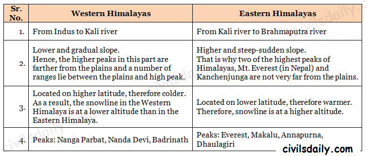
1. The snowline in the Western Himalaya is at a lower altitude than in the Eastern Himalaya. E.g. while the glaciers of the Kanchenjunga in the Sikkim portion hardly move below 4000m, and those of Kumaon and Lahul to 3600m, the glaciers of the Kashmir Himalayas may descend to 2500m above the sea level.
- It is because of the increase in latitude from 28°N in Kanchenjunga to 36°N in the Karakoram (Lower latitude —> warmer temperatures —> higher snowline).
- Also, the Eastern Himalayas rise abruptly from the planes without the intervention of High ranges.
- Though the total precipitation is much less in the western Himalayas, it all takes place in the form of snow.
2. In the Great Himalayan ranges, the snowline is at a lower elevation on the southern slopes than on the northern slopes. This is because the southern slopes are steeper and receive more precipitation as compared to the northern slopes.
Glaciers: The main glaciers are found in the Great Himalayas and the Trans-Himalayan ranges (Karakoram, Ladakh and Zaskar). The Lesser Himalayas have small glaciers, though traces of large glaciers are found in the Pir Panjal and Dhauladhar ranges. Some of the important glaciers are:

Key differences between the Eastern and Western Himalayas:
Important Passes in India:
A pass is a narrow gap in a mountain range which provides a passageway through the barrier.
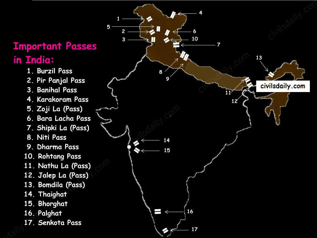
- Pir Panjal Pass – It provides the shortest and the easiest metal road between Jammu and the Kashmir Valley. But this route had to be closed down as a result of partition of the subcontinent.
- Banihal Pass – It is in Jammu and Kashmir. The road from Jammu to Srinagar transversed Banihal Pass until 1956 when Jawahar Tunnel was constructed under the pass. The road now passes through the tunnel and the Banihal Pass is no longer used for road transport.
- Zoji La (Pass) – It is in the Zaskar range of Jammu and Kashmir. The land route from Srinagar to Leh goes through this pass.
- Shipki La (Pass) – It is in Himachal Pradesh. The road from Shimla to Tibet goes through this pass. The Satluj river flows through this pass.
- Bara Lacha Pass – It is also in Himachal Pradesh. It links Mandi and Leh by road.
- Rohtang Pass – It is also in Himachal Pradesh. It cuts through the Pir Panjal range. It links Manali and Leh by road.
- Niti Pass – It is in Uttarakhand. The road to the Kailash and the Manasarovar passes through it.
- Nathu La (Pass) – It is in Sikkim. It gives way to Tibet from Darjeeling and Chumbi valley. The Chumbi river flows through this pass.
- Jalep La (Pass) – At the tri-junction of India- China-Bhutan. The Teesta river has created this pass.
B) The North-Eastern Hills and Mountains
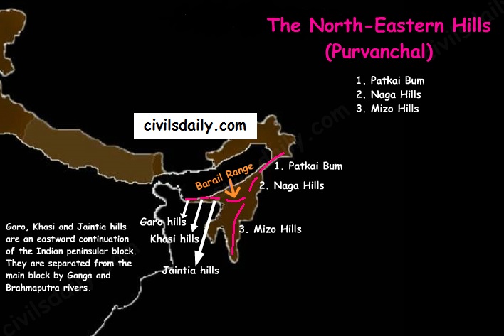
The Brahmaputra marks the eastern border of Himalayas. Beyond the Dihang gorge, the Himalayas bend sharply towards south and form the Eastern hills or Purvanchal.
- These hills run through the northeastern states of India.
- These hills differ in scale and relief but stem from the Himalayan orogeny.
- They are mostly composed of sandstones (i.e. Sedimentary rocks).
- These hills are covered with dense forests.
- Their elevation decreases from north to south. Although comparatively low, these hill ranges are rather forbidding because of the rough terrain, dense forests and swift streams.
- Purvanchal hills are convex to the west.
- These hills are composed of:
- Patkai Bum – Border between Arunachal Pradesh and Myanmar
- Naga Hills
- Manipuri Hills – Border between Manipur and Myanmar
- Mizo Hills.
- Patkai Bum and Naga Hills form the watershed between India and Myanmar.
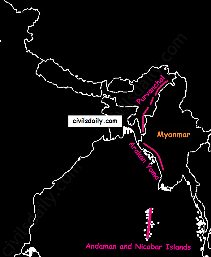
- Extension of Purvanchal continues in Myanmar as Arakan Yoma –then Andaman and Nicobar Islands.
