The Indian Drainage System
The Indian drainage system consists of a large number of small and big rivers.
It is an outcome of:
- The evolutionary process of the three major physiographic units
- The nature and characteristics of precipitation.

Classification of Drainage Systems in India:
1. On the basis of discharge of water – the Arabian Sea drainage and the Bay of Bengal drainage:
On the basis of discharge of water (orientations to the sea), the drainage system of India may be grouped into:
- the Arabian Sea drainage
- the Bay of Bengal drainage
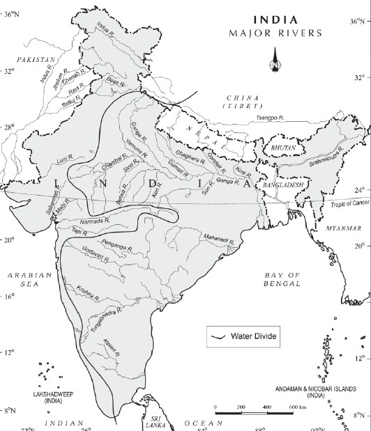
They are separated from each other by the Delhi ridge, the Aravalis and the Sahyadris (water divide is shown by a line in the following map).

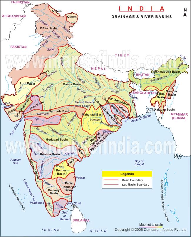
Nearly 77 percent of the drainage area consisting of the Ganga, the Brahmaputra, the Mahanadi, the Krishna, etc. is oriented towards the Bay of Bengal while 23 percent comprising the Indus, the Narmada, the Tapi, the Mahi and the Periyar systems discharge their waters in the Arabian Sea.
1. Rivers of the inland drainage basin (endorheic basin): When a river does not reach the sea but disappears into the sand, such a region is called an area of inland drainage. Inland drainage streams are ephemeral streams (short-lived). E.g.:
- The Ghaggar river in Haryana, which is supposed to be remnant of the proverbial ancient Saraswati river, gets lost in dry sands near Hanumangarh in Rajasthan.
- The Luni river in Rajasthan originates near Ajmer and after flowing through Thar desert gets lost in the Rann of Kutch.
- The Aksai Chin region in Ladakh too has some inland drainage.
2. On the basis of the size of the watershed:
- Major river basins – with more than 20,000 sq. km of catchment area. It includes 14 drainage basins such as the Ganga, the Brahmaputra, the Krishna, the Tapi, the Narmada, the Mahi, the Pennar, the Sabarmati, the Barak, etc.
- Medium river basins – with catchment area between 2,000-20,000 sq. km incorporating 44 river basins such as the Kalindi, the Periyar, the Meghna, etc.
- Minor river basins – with catchment area of less than 2,000 sq. Km, these include 55 river basins.
3. On the basis of the mode of origin, nature and characteristics:
- The Himalayan drainage, and
- The Peninsular drainage.
There is no clear-cut line of demarcation between these two drainage systems, as many of the peninsular rivers like the Chambal, Betwa, Sind, Ken and Son are much older in age and origin than the Himalayan rivers.
Let’s follow this line of classification and look at the drainage system of India in detail. We begin with the Himalayan drainage.
The Himalayan Drainage system:
- It consists of the rivers originating in the Himalayan and trans-Himalayan region. It further consists of three river systems namely:
- the Ganga,
- the Indus, and
- the Brahmaputra river systems.
- Since these are fed both by the melting of snow and precipitation, rivers of this system are perennial.
- The various geographical features made by the Himalayan rivers are:
- In upper reaches (Youthful stage): Gorges, V-shaped valleys, rapids, waterfalls, truncated spurs etc.
- In plain areas or middle part (Mature stage): While entering the plains, they form depositional features like flat valleys, ox-bow lakes, flood plains, braided channels, and deltas near the river mouth. Over the plains, they display a strong meandering tendency and shift their courses frequently.
Evolution of the Himalayan Drainage System:
There is a difference of opinion about the evolution of the Himalayan Rivers. However, geologists believe that:
- A mighty river called Shiwalik or Indo-Brahma traversed the entire longitudinal extent of the Himalaya from Assam to Punjab and onwards to Sind, and finally discharged into the Gulf of Sind near lower Punjab during the Miocene period some 5-24 million years ago.
Evidences: The remarkable continuity of the Shiwalik and its lacustrine origin and alluvial deposits consisting of sands, silt, clay, boulders and conglomerates support this viewpoint.
- It is opined that in due course of time Indo–Brahma river was dismembered into three main drainage systems:
- the Indus and its five tributaries in the western part;
- the Ganga and its Himalayan tributaries in the central part; and
- the stretch of the Brahmaputra in Assam and its Himalayan tributaries in the eastern part.
The dismemberment was probably due to the Pleistocene upheaval in the western Himalayas, including the uplift of the Potwar Plateau (Delhi Ridge), which acted as the water divide between the Indus and Ganga drainage systems.
Likewise, the downthrusting of the Malda gap area between the Rajmahal hills and the Meghalaya plateau during the mid-pleistocene period, diverted the Ganga and the Brahmaputra systems to flow towards the Bay of Bengal.
Let’s take up the three major river systems of the Himalayan drainage individually:
1. The Indus River System
- It is one of the largest river basins of the world. A little over one-third of the Indus basin is located in India; in the states of Jammu & Kashmir, Himachal Pradesh and Punjab. The rest of the portion is in Pakistan.
- The Indus also known as the Sindhu, is the westernmost of the Himalayan rivers in India.
- Origin: It originates from a glacier near Bokhar Chu in the Kailash Mountain range (Tibetan region). In Tibet, it is known as ‘Singi Khamban; or Lion’s mouth.
- The river-course:
- The Indus cuts through Himalayas and enters India near Damchok.
- flows in India only through the Leh district in Jammu and Kashmir.
- It enters into Pakistan near Chillar in the Dardistan region through a deep gorge near the hair-pin bend of Nanga Parbat.
- It finally discharges into the Arabian Sea, east of Karachi.
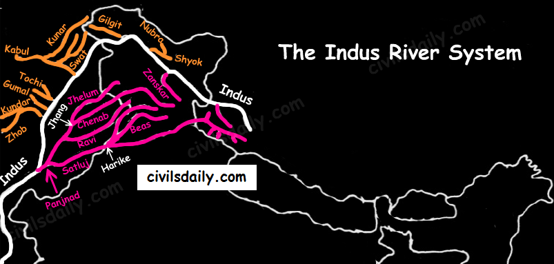
- The right-bank tributaries of Indus:
- Shyok
- Gilgit
- Hunza
- Nubra
- Kabul
- Khurram
- Tochi
- Gomal
- Sangar
- Kunar
- The left-bank tributaries of Indus:
- Zaskar
- ‘Panjnad’ joins Indus a little above Mithankot). The Panjnad is the name given to the five rivers of Punjab, namely:
- Satluj
- Beas
- Ravi
- Chenab
- Jhelum
- Chief Characteristics:
- The Indus drains the largest number of glaciers of Himalayas, Ladakh, Zaskar, and Kailash.
- The Indus plain has a very gentle slope.

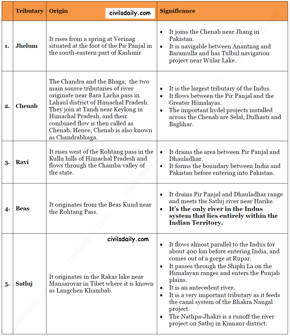
Let’s look at some important tributaries of Indus:

The Indus water treaty: The waters of the Indus river system are shared by India and Pakistan according to the Indus Water Treaty signed between the two countries on 19th September 1960. According to this treaty, India can utilise only 20 percent of its total discharge of water. The Indus water treaty was recently in news. Remember why? Read here!

