There are two major island groups in India
- The island groups of Bay of Bengal: Andaman & Nicobar Islands
- The island groups of Arabian Sea: Lakshadweep and Minicoy Islands

Let’s take these up one by one:
Andaman & Nicobar Islands:
- Also called the emerald islands.
- Location and Extent:
- These are situated roughly between 6°N-14°N and 92°E -94°E.
- The most visible feature of the alignment of these islands is their narrow longitudinal extent.
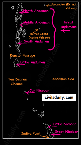
- These islands extend from the Landfall Island in the north (in the Andamans) to the Indira Point (formerly known as Pygmalion Point and Parsons Point) in the south (In the Great Nicobar).
- Origin: The Andaman and Nicobar islands have a geological affinity with the tertiary formation of the Himalayas, and form a part of its southern loop continuing southward from the Arakan Yoma.
- The entire group of islands is divided into two broad categories:
- The Andaman in the north, and
- The Nicobar in the south.
They are separated by a water body which is called the Ten degree channel.
- The Andaman islands are further divided into:
- Great Andamans
- North Andaman
- Middle Andaman
- South Andaman
- Little Andaman
- Great Andamans
Little Andaman is separated from the Great Andamans by the Duncan Passage.

- Chief Characteristics:
- These are actually a continuation of Arakan Yoma mountain range of Myanmar and are therefore characterized by hill ranges and valleys along with the development of some coral islands.
- Some smaller islands are volcanic in origin e.g. the Barren island and the Narcondam Island. Narcondam is supposed to be a dormant volcano but Barren perhaps is still active.
- These islands make an arcuate curve, convex to the west.
- These islands are formed of granitic rocks.
- The coastal line has some coral deposits, and beautiful beaches.
- These islands receive convectional rainfall and have an equatorial type of vegetation.
- These islands have a warm tropical climate all year round with two monsoons.
- The Saddle peak (North Andaman – 738 m) is the highest peak of these islands.
- The Great Nicobar is the largest island in the Nicobar group and is the southernmost island. It is just 147 km away from the Sumatra island of Indonesia.
Lakshadweep Islands:
- These islands were earlier (before 1st November 1973) known as Laccadive, Minicoy and Amindivi Islands.
- Location:
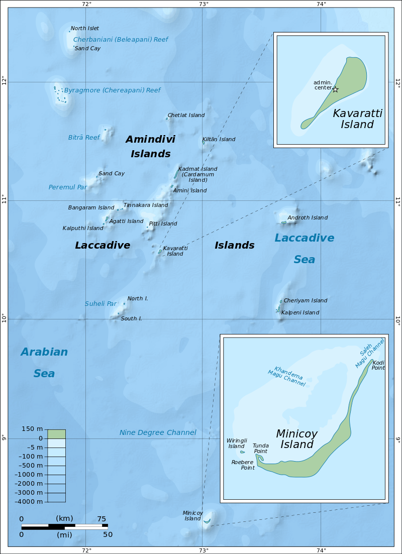
- These are scattered in the Arabian Sea between 8°N-12°N and 71°E -74°E longitude.
- These islands are located at a distance of 280 km-480 km off the Kerala coast.
- Origin: The entire island group is built of coral deposits.
- Important islands:
- Amindivi and Cannanore islands in the north.
- Minicoy (lies to the south of the nine degree channel) is the largest island with an area of 453 sq. km.
Source
- Chief Characteristics:
- These consist of approximately 36 islands of which 11 are inhabited.
- These islands, in general, have a north-south orientation (only Androth has an East-West orientation.
- These islands are never more that 5 metres above sea level.
- These islands have calcium rich soils- organic limestones and a scattered vegetation of palm species.
- One typical feature of these islands is the formation of crescentic reef in the east and a lagoon in the west.
- Their eastern seaboard is steeper.
- The Islands of this archipelago have storm beaches consisting of unconsolidated pebbles, shingles, cobbles and boulders on the eastern seaboard.
- The islands form the smallest Union Territory of India.
Other than the above mentioned two major groups, the important islands are:
- Majauli: in Assam. It is:
- The world’s largest freshwater (Brahmaputra river) island.
- India’s first island district
- Salsette: India’s most populous island. Mumbai city is located on this island.
- Sriharikota: A barrier island. On this island is located the satellite launching station of ISRO.
- Aliabet: India’s first off-shore oil well site (Gujarat); about 45 km from Bhavnagar, it is in the Gulf of Khambat.
- New Moore Island: in the Ganga delta. It is also known as Purbasha island. It is an island in the Sunderban deltaic region and it was a bone of contention between India and Bangladesh. In 2010, it was reported to have been completely submerged by the rising sea water due to Global warming.
- Pamban Island: lies between India and Sri Lanka.
- Abdul Kalam Island: The Wheeler Island near the Odisha coast was renamed as Abdul Kalam island in 2015. It is a missile launching station in the Bay of Bengal. The first successful land-to-land test of the Prithvi Missile was conducted from the mainland and it landed on the then uninhabited ‘Wheeler Island’ on November 30, 1993.
Now that we are done with this part, let’s try to attempt some questions from the past UPSC examinations:
Prelims:
1996
Question: ‘Saddle Peak’ the highest peak of Andaman and Nicobar islands is located in
A. Great Nicobar
B. Middle Andaman
C. Little Andaman
D. North Andaman
Ans. D
Mains:
Question: Write a short note on New Moore Island. (2006/2M)
Question: Write a short note on Indira Point. (2007/2M)
Question: Name the main physiographic divisions of India and give the salient features of each division. (2000/15M).
Question: How do the Andaman and Nicobar Islands and the Lakshadweep differ in the geological evolution and topographical conditions? (1998/15M)


thanks for this article