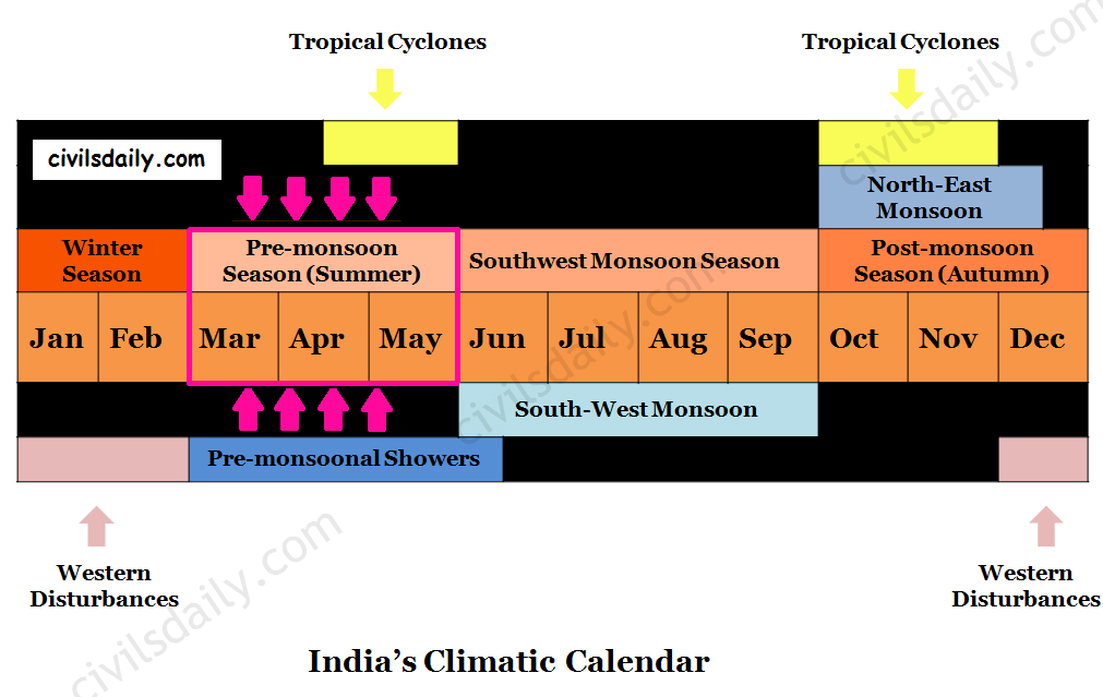
Temperature Conditions during this season:
- As the sun shifts northward towards the Tropic of Cancer after the vernal Equinox, the whole India experiences an increase in temperature.
- In most parts of India, temperatures recorded are between 30°-32°C.
North India:
- April, May and June are the months of summer in north India.
- In May, the heat belt moves further north, and in the north-western part of India, temperatures around 48°C are not uncommon.
South India:
- The Peninsular situation of south India with moderating effect of the oceans keeps the temperatures lower than that prevailing in north India. So, temperatures remain between 26°C and 32°C.
- Western Ghats – Due to altitude, the temperatures in the hills of Western Ghats remain below 25°C.
- The temperature increases from the coast towards the interior areas.
Surface Pressure and Winds:
- The atmospheric pressure is low all over the country due to high temperatures.
- Since the sun goes gradually towards the north (summer solstice), the Inter Tropical Convergence Zone (ITCZ) begins to move towards the north (Eventually reaching up to 25° latitude in July).
- The general direction of winds is from the north-west and west in north-western India, and from the south-west in the Arabian Sea and adjoining coasts.
- In the months of May and June, the high temperature in north-western India builds steep pressure gradient.
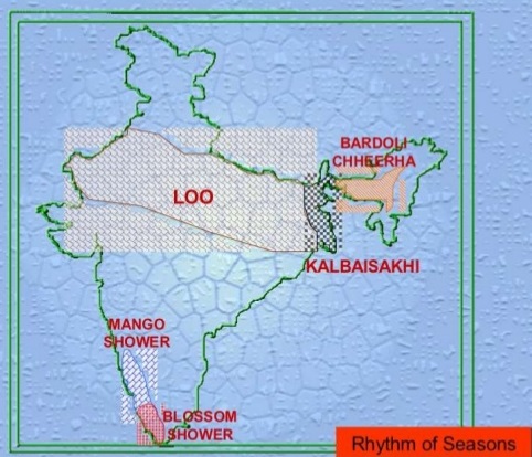
- Under such conditions, hot dust-laden strong winds known as ‘loo’ blow.
- These strong dust storms result from the convective phenomenon and their intensity increases in the afternoon. These are locally known as Andhis.
- These are essentially short-lived thunderstorms, which move like a solid wall of sand and dust.
- These bring little rainfall and give much needed relief from heat.
- Dust storms in the evening are very common during May in Punjab, Haryana, Eastern Rajasthan and Uttar Pradesh.

A Dust Storm in Delhi this May. Image Source
Pre monsoonal showers:
- Occasionally, the moisture-laden winds are attracted towards the periphery of the trough. A sudden contact between dry and moist air masses gives rise to local storms of great intensity. These local storms are associated with violent winds, torrential rains and even hailstorms.
- The thunderstorms which originate over Chotanagpur plateau are carried eastwards by westerly winds. The areas with the highest incidence of thunderstorms are the north-eastern states, West Bengal, and the adjoining areas of Orissa and Jharkhand.
- In West Bengal and the adjoining areas of Assam, Orissa and Jharkhand, the direction of squalls is mainly from the northwest and they are called Norwesters (Squall – a sudden, violent gusty wind).
- The rainfall brough by norwesters is called spring storm showers.
- These are often very violent with squall speeds of 60-80km/hour.
- Large sized hailstones sometimes accompany these showers and harm the animals and standing crops.
- The period of maximum occurrence of these storms is the month of Baisakh. These are thus locally called ‘Kal Baisakh (a calamity of the month of Baisakh)’.
- In Assam, these storms are known as “Bardoli Chheerha or Bordochila”.
- In the south, thunderstorms occur in Kerala and adjoining parts of Karnataka and Tamil Nadu particularly in the evenings and nights. These pre-monsoonal showers are called by various names:
- Tea showers in Assam ( they are good for tea, jute and rice)
- Mango showers in Kerala and coastal areas of Karnataka as they help in the early ripening of mangoes.
- Cherry Blossoms/ Coffee showers in Kerala and nearby areas (good for coffee plantations)

Tropical Cyclones:
Tropical Cyclones (TC) are intense low-pressure systems that develop over the seas or oceans in the tropical and subtropical regions. Tropical cyclones cause destruction in the coastal areas because of:
- High wind velocities.
- Storm Surge ( i.e. rise of coastal waters due to approaching cyclone)
- Torrential rainfall which often lead to floods in the coastal areas.
Note: The interior regions do benefit from the torrential rain associated with a tropical cyclone for agriculture and other applications of water.
The Indian sub-continent having a coast line of 7516 km is the worst affected region of the world. It is exposed to nearly 10% of the world’s Tropical Cyclones.
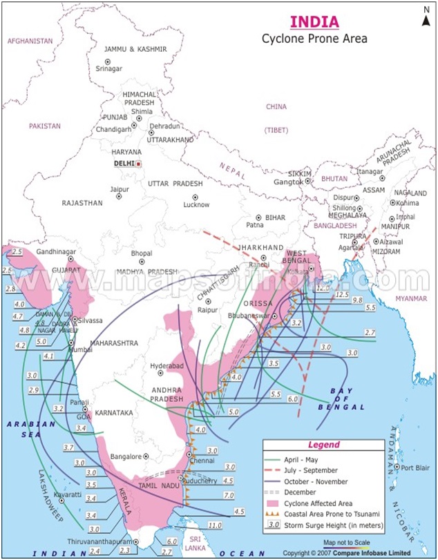
- Many low-pressure systems of varying stages of development form in the Bay of Bengal and in the Arabian Sea and move west or north-westwards, sometimes re-curving north or north-east at a later stage (See the following map ). Re-curvature usually occurs when these systems are between 16° and 18°N.
- Only a few of them develop fully into the mature stage and the majority remain as depressions.
- The fully developed low-pressure systems called cyclones generally form in the lower latitude belt (10° N – 14°N) before and after the SW monsoon. They are very intense systems and are responsible for the major portion of rainfall over the peninsula.
- These systems reach their maximum intensity before/after the monsoon period.
- During the SW monsoon season, these systems form in the Bay of Bengal and generally travel west or north-west along the monsoon trough. The rainfall over northern India is to a large extent dependent on the frequency, track and intensity of these depressions (called monsoon depressions). The frequency and direction of these cyclones also influence weather conditions along the eastern coast during retreating monsoon season i.e. in October and November.
- An analysis of the frequencies of cyclones on the East and West coasts of India shows that the East Coast is more prone to tropical cyclones as compared to the West Coast.


