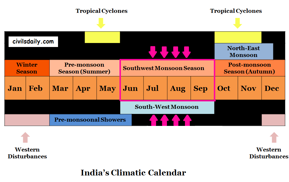
Chief Characteristics of Monsoonal Rainfall:
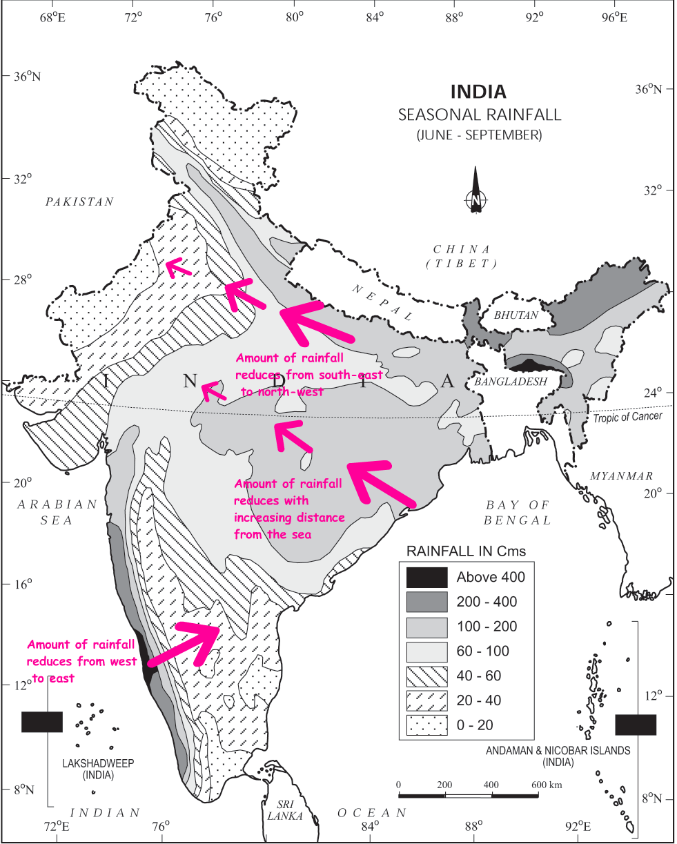
- Monsoonal rainfall is largely governed by relief or topography. For example:
- The windward side of the Western Ghats registers a rainfall of over 250 cm.
- The heavy rainfall in the north-eastern states can be attributed to their hill ranges and the Eastern Himalayas.
- The monsoon rainfall has a declining trend with increasing distance from the sea. E.g. consider the amount of rainfall received during the south-west monsoon period at the following places:
Kolkata (119 cm) –> Patna (105 cm) –> Allahabad (76 cm) –> Delhi (56 cm)
- The rain comes in spells and displays a declining trend from west to east over the west coast, and from the south-east towards the north-west over the North Indian Plain and the northern part of the Peninsula.
- Its spatial distribution is also uneven which ranges from 12 cm to more than 250 cm.
What causes monsoons?
Monsoon is a familiar though a little known climatic phenomenon. Despite the observations spread over centuries, the monsoon continues to puzzle the scientists. Many attempts have been made to discover the exact nature and causation of monsoon, but so far, no single theory has been able to explain the monsoon fully.
Let’s look at some of the important concepts about the origin of monsoons. We will study these along the following lines:
- The Classical Hypothesis
- Halley(1690’s)
- Hadley (1730’s)
- The role of moisture.
- The shifting of ITCZ – Flohn
Recent theories:
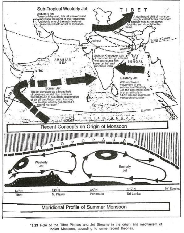
- The role of Tibetan plateau
- As a mechanical barrier
- As a high-level heat source
- The role of jetstreams
- The Sub-tropical/ tropical westerly jetstream
- The tropical/ equatorial easterly jetstream
1. The Classical Hypothesis
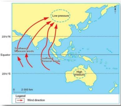
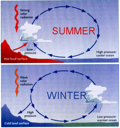
Halley hypothesized that the primary cause of the annual cycle of Indian monsoon circulation was a differential heating effect between the ocean and land in South Asia.
- During April and May when the sun shines vertically over the Tropic of Cancer, the large landmass in the north of Indian ocean gets intensely heated. This causes the formation of an intense low pressure in the northwestern part of the subcontinent.
- The pressure in the Indian Ocean in the south of the landmass is high as water gets heated slowly.
- This pressure differences causes the flow of winds from the high pressure to low pressure areas
Thus the first model ever proposed about the mechanism of the Indian monsoon was Haley’s planetary scale sea-breeze – land breeze system in 1690’s.
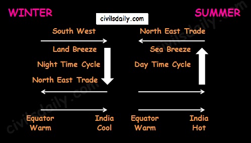
Hadley later argued that Haley’s model was lacking in the physical ingredient of the effect of rotation of earth about its axis. Hadley reasoned that the monsoon originates in the SE trades of the southern hemisphere and as it flows across the equator towards the heated landmass, the coriolis force causes it to turn to right, thereby forming the summer monsoon or the SW monsoon.
Image Source
2. The role of moisture:
Moisture plays an important role in the atmospheric circulation which was not appreciated by either Halley or Hadley.
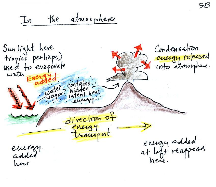
In this respect, the release of latent heat augments the differential heating produced by the land-sea contrast by providing a mechanism for the solar energy received over the vast stretches of the Indian Ocean to be collected, stored, concentrated and later released over the parched landscape of India by a massive atmospheric motion (See the following image to understand this transfer of solar energy) . As the moisture laden air comes over India, with its upliftment there takes place condensation releasing latent heat – augmenting the low pressure conditions i.e. the cause getting augmented by its effect.
Image Source
The shifting of ITCZ – Dr. Flohn
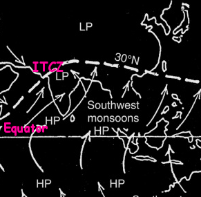
The existence of Asian monsoon according to Dr. Flohn is not due to the temperature contrast between land and sea but primarily due to the annual migration of thermally induced planetary winds and pressure belts. For Flohn, the winter monsoon is nothing but the tropical easterlies or the northern trade winds. According to Flohn, the SW monsoon is constituted by the equatorial westerlies which have been displaced northward (because of shift of ITCZ by 20° or more).
Recent Theories:
1. The role of Tibetan Plateau:
A remarkable aspect of the large scale circulation during the summer monsoon season over south-Asia is the upper tropospheric anti-cyclone situated over the Tibetan Plateau.
- The Tibetan Plateau located more than 4500m above mean sea-level with a length of 2000km and width of 600km in the west and 1000km in the east, is considered to be one of the key factors in the development of monsoon circulation in the region.
- The Tibetan plateau exerts its influence both as a mechanical barrier in the atmospheric flow as well as a high level heat source.
- An anti-cyclone appears in the upper troposphere over Tibet during the Indian monsoon season primarily due to latent and sensible heating over the plateau.
- This anti cyclone appears over south-east Asia in the month of May and then moves north-westwards, reaching Tibetan plateau around the height of the summer monsoon season.
- From about September, the anticyclone migrates south-eastward towards Indonesia and loses definition after October.
- Variations in the intensity and position of this High and its orientation have been found to be closely related to the monsoon circulation over South Asia.
The role of Jet streams:
Jet streams which affect India’s monsoon:
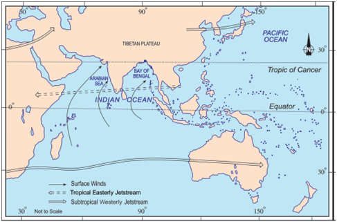
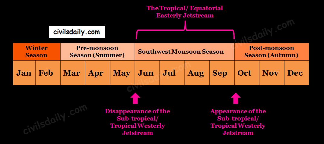
1. Sub tropical/ Tropical Westerly Jet stream (TWJS) ~27°N
- (Covered in detail in the discussion on winter season. Need to revise? Click here!)
- According to Dr. Koteshwaram, the disappearance of this jet from the south of the Himalayas paves the way for the burst of South-West Monsoon along the coast of Kerala.
2. Tropical/ Equatorial Easterly Jet stream (TEJS) ~14°N
- This jet is a prominent feature of the upper air circulation during the Indian summer monsoon season (June – September). It appears as a band of strong easterlies extending from SE Asia across the Indian Ocean and Africa to the Atlantic, generally at a height of about 14 kms. It is present over south Indian peninsula between 12° and 15°N with a mean position of 14°N. This easterly jet stream is held responsible for the burst of the monsoon in India.
- The position and speed of this jet have been found to have significant spatial and temporal fluctuations, which in turn correlate with monsoon rainfall distribution over peninsular India.
Factors which influence the South-West monsoon intensity and rainfall distribution:
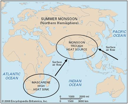
- Mascarene High and the Somali Jetstream: It is the high pressure area at sea level south of the equator in the Indian Ocean near Mascarene Islands. The position and intensity of this high are considered to be closely linked to the south summer monsoon activity.
According to scientists, the broad belt of high pressure around the Mascarene Islands generates a cross-equatorial flow known as the Somali Jet which brings heavy rain to India’s west coast. A strong, low level jet usually means a strong monsoon over peninsular India.
Image Source
- Variation in the axis of the monsoon trough: The monsoon trough axis experiences considerable day to day variation in its position, which has a vital bearing on the monsoon rainfall distribution in the region. During the break monsoon periods, when there is a temporary lull in monsoon activity, the trough line shifts to the foothills of the Himalayas. Rainfall over the central parts of India decreases considerably and there is an increase in rainfall over northern India along the Himalayan foothills.
- Teleconnections (ENSO – El–Nino and Southern Oscillation Index):
A. Southern Oscillation Index (SOI)
-
- A curious see-saw pattern of meteorological changes has been observed b/w Indian Ocean & Pacific ocean. Whenever pressure is higher over Indian Ocean, low pressure prevails over Pacific Ocean & vice versa. This see-saw relationship is referred to as the Southern Oscillations.
- To measure this pressure difference, a SOI has been developed based on the pressure data at certain representative stations (e.g. the SOI between Tahiti island and Darwin is the most widely used)
SOI (Southern Oscillation Index) = (Atm. Pressure @Tahiti) – (Atm. Pressure @Darwin)
Tahiti = Pacific Ocean, Darwin = Indian Ocean
B. El-Nino (Spanish for male child)
-
- It is an anomalous warming of the Eastern Tropical Pacific Ocean that occurs at 2 – 10 years intervals and is frequently associated with far reaching climatic and oceanic impacts around the world.
These two are believed to be inter-connected – the southern oscillation has been identified as the atmospheric counterpart to El-Nino. Both are together referred to as ENSO.
During the high southern oscillation phase (Normal situation), precipitation tends to be abundant in the Indonesian – Australian region, most of the south Asian region, SE Africa and northern coast of South America. Relatively dry conditions prevail over the equatorial pacific, east central Africa and northern Mexico.
During the low phase of the southern oscillation (El-Nino), the rainfall anomalies are approximately opposite. The El-Nino is found to be adversely correlated with the SW monsoon rain.
La-Nina (Spanish for girl child) refers to the reinforced normal situation and is found to be positively correlated with the SW monsoon rain.
