Temperature Conditions during this season:
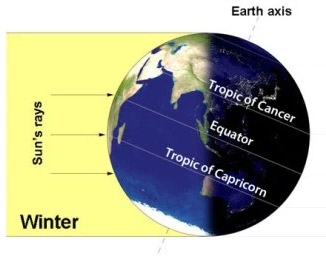
By the end of December (22nd December), the sun shines vertically over the Tropic of Capricorn in the southern hemisphere. So, India which is located in the northern hemisphere experiences low temperatures. January and February are the coldest months over most parts of the country.
Image Source
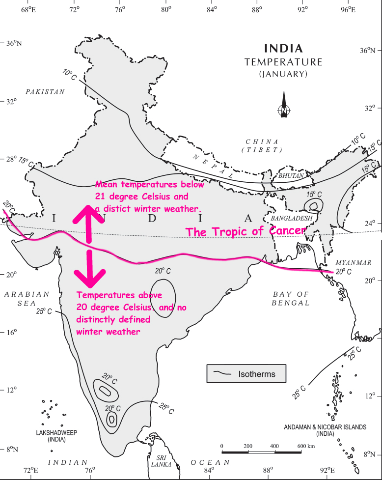
The isotherm of 20°C runs roughly parallel to the Tropic of Cancer.
The northern region:
This season usually begins in late-November in northern India. Lowest temperatures are observed in Punjab and Rajasthan. December and January are the coldest months in the northern plain. The night temperature may be quite low, sometimes going below freezing point in Punjab and Rajasthan.
There are three main reasons for the excessive cold in north India during this season:
- States like Punjab, Haryana and Rajasthan being far away from the moderating influence of sea experience continental climate.
- The snowfall in the nearby Himalayan ranges creates cold wave situation; and
- Around February, the cold winds coming from the Caspian Sea and Turkmenistan bring cold wave along with frost and fog over the northwestern parts of India.
The peninsular region:
The Peninsular region of India, however, does not have any well-defined cold weather season. There is hardly any seasonal change in the distribution pattern of the temperature in coastal areas because of:
- Moderating influence of the sea, and
- Proximity to the equator.
Distribution of air pressure and winds on the surface of the earth:
In winter months, the weather conditions over India are generally influenced by the distribution of pressure in the Central and Western Asia.
- A high-pressure centre in the region lying to the north of the Himalayas develops during winter.
- This centre of high pressure gives rise to the flow of air from the north towards the Indian subcontinent, south of the mountain range.
- These surface winds blowing out of the high-pressure centre over Central Asia reach India in the form of a dry continental air mass.
- These continental winds come in contact with trade winds over northwestern India. The position of this contact zone is not, however, stable. Occasionally, it may shift its position as far east as the middle Ganga valley with the result that the whole of the northwestern and northern India up to the middle Ganga valley comes under the influence of dry northwestern winds.
- In south India, the air pressure is slightly lower (due to higher temperatures). As a result, winds start blowing from northwestern high-pressure zone to the low air pressure zone over the Indian Ocean in the south. Due to a low pressure gradient, the light winds blow outwards with a low velocity of about 3-5 km per hour.
- By and large, the topography of the region influences the wind direction (See the following map):
- They are westerly or northwesterly down the Ganga Valley.
- They become northerly in the Ganga-Brahmaputra delta.
- Free from the influence of topography, they are clearly north-easterly over the Bay of Bengal.
- These land bearing winds being cold and dry don’t give rain over most parts of the country. However, these winds cause rain along the Coromandel Coast since they collect moisture on their way over the Bay of Bengal.
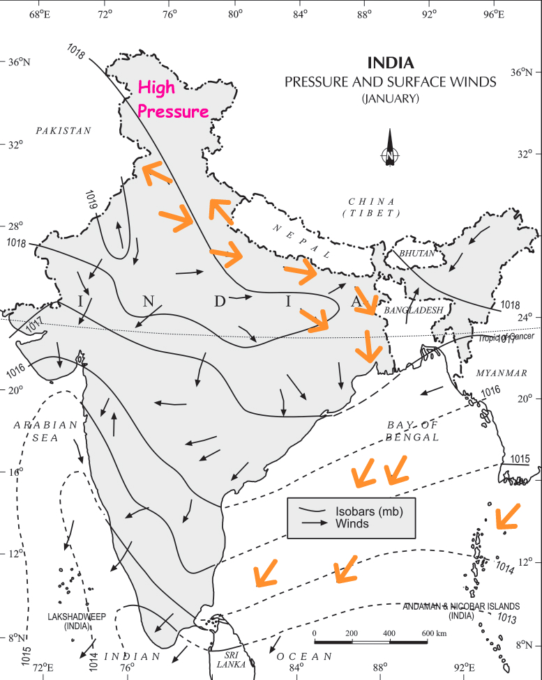
Image Source – NCERT ClassXI
Jet Stream and Upper Air Circulation:
Higher up in the atmosphere, a different pattern of air circulation is observed during the winter months:
- All of Western and Central Asia remains under the influence of westerly winds along the altitude of 9-13 km from west to east. These winds blow across the Asian continent at latitudes north of the Himalayas roughly parallel to the Tibetan highlands. These are known as the sub-tropical/tropical westerly jet stream.
- Tibetan highlands act as a barrier in the path of these jet streams. As a result, jet streams get bifurcated. One of its branches blows to the north of the Tibetan highlands, while the southern branch blows in an eastward direction, south of the Himalayas, later recombining into a single stream over China.
- It is believed that this southern branch of the jet stream exercises an important influence on the winter weather in India.
- The mean position of this jetstream is about 25°N.
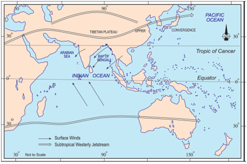
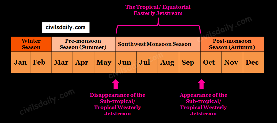
- This jetstream first appears over the northern parts of the Indian subcontinent in the month of October after the withdrawal of the summer monsoon and shifts progressively southwards with the advance of the winter season. Thereafter, it shifts back towards the north, weakens and disappears from the South Asian region with the establishment of the South-West monsoon in June. According to Dr.Koteshwaram, the disappearance of this jet from the south of the Himalayas paves the way for the burst of South-West Monsoon along the coast of Kerala.
Western Disturbances:
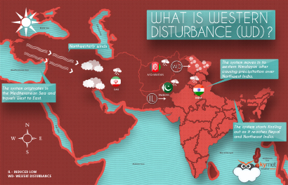
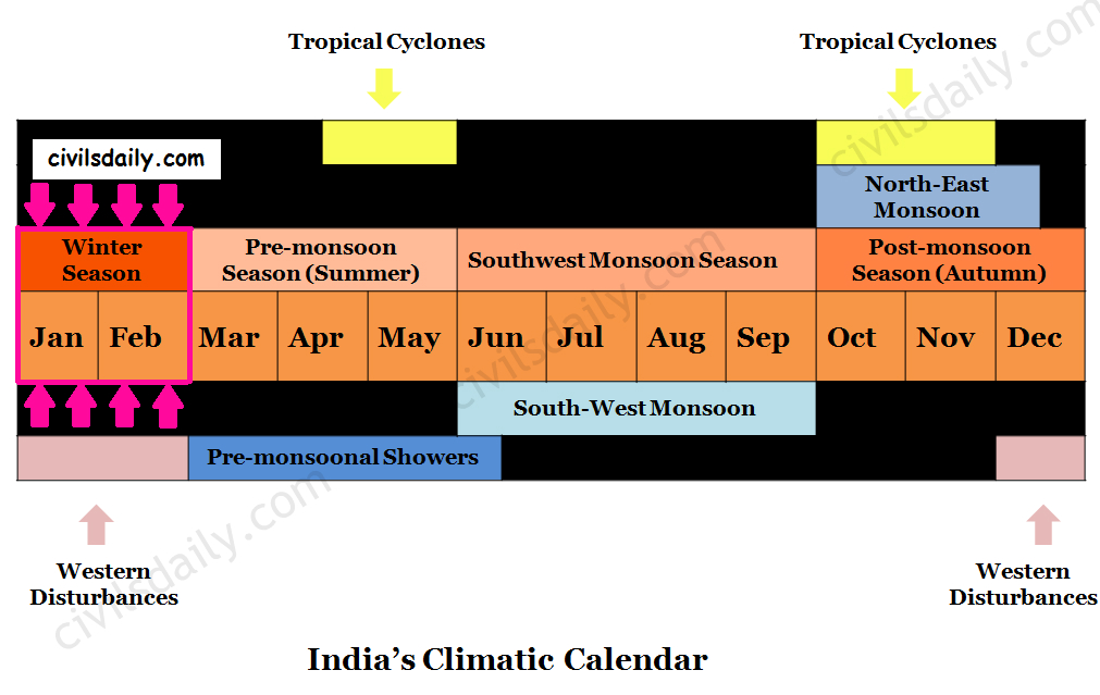
During the winters, the weather in India is pleasant. The pleasant weather conditions, however, at intervals, get disturbed by shallow cyclonic depressions originating over the east Mediterranean Sea.
- These temperate cyclones travel eastwards across West Asia, Iran, Afghanistan and Pakistan and enter the north-western parts of India with the help of the westerly jetstream (discussed above).
- On their way, the moisture content gets augmented from the Caspian Sea in the north and the Persian Gulf in the south. Since these extratropical cyclones reach India from the West, they are usually referred to as the western disturbances over the Indian region.
Image Source
- Because of the high terrain, mountain ranges, most of these disturbances are in the mature stage and hence weak or irregular by the time they reach India.
- Reaching Rajasthan, Haryana and Punjab, these disturbances slow down and stagnate due the nearly closed in nature of the region with high hills.
- With moisture feed from the Arabian Sea, these disturbances may intensify and move north-east. The tracks of these disturbances come farthest south to latitudes 22/23°N in the month of February.
- An increase in the prevailing night temperature generally indicates an advance in the arrival of these disturbances.
The western disturbances result in:
- A cold spell in north-western India as these depressions are followed by cold waves.
- Winter rainfall in Punjab, Haryana, Delhi and western Uttar Pradesh, locally known as ‘mahawat’. Although the amount is meagre, it is highly beneficial for Rabi crops.
- Snowfall in the higher altitudes of Kashmir and Himachal Pradesh and sometimes hail too. It is this snow that sustains the flow of water in the Himalayan rivers during the summer months.
The precipitation goes on decreasing from west to east in the plains and from north to south in the mountains.
Note: The term western disturbance is generally applied to all disturbances which come from the West, even when a “low” may not be seen on the synoptic charts.
