Note4Students
From UPSC perspective, the following things are important :
Prelims level: Naini Lake
Why in the News?
Naini Lake, one of Nainital’s key attractions, has recorded a water level of 4.7 feet, marking a 5-year low, sparking concerns about drinking water scarcity as the summer season approaches.
About Naini Lake
- Naini Lake is situated in the heart of Nainital, a hill station in the Indian state of Uttarakhand. It is surrounded by seven hills.
- The lake is natural kidney-shaped and is one of the main attractions of Nainital.
- It was discovered by P. Barron, an English businessman, in the mid-19th century, which led to the development of Nainital as a hill station.
- The deepest point of Naini Lake is 89 feet.
- The normal gauge level of the lake is 12 feet, and its water level has recently dropped to 4.7 feet, marking a five-year low.
Why is the Water Level declining?
- The Uttarakhand Jal Sansthan extracts 10 million litres of water daily from Naini Lake for drinking water supply to the city of Nainital.
- 76% of the city’s water demand was met by the lake in 2024, but increasing population, tourist activity, and commercialisation have intensified pressure on the lake’s water resources.
- The lake faces numerous threats, including:
- Decreased snowfall and rainfall, especially in the winter months.
- Unplanned construction and encroachments around the lake, leading to the reduction of its catchment area.
- Pollution due to the discharge of untreated wastewater and improper disposal of solid waste.
- Siltation caused by debris dumping in Sukhatal Lake, a major aquifer recharge area for Naini Lake, has contributed to the shrinking of the lake’s size.
- Climate change is affecting the region’s weather patterns, with annual temperatures rising by nearly 1.5 degrees Celsius between 1970 and 2022.
|
Other Important Lakes in India (Artificial and Manmade):
| Type |
Lake Name |
Location |
Details |
| Natural |
Dal Lake |
Jammu & Kashmir |
Famous for houseboats and scenic beauty, located in Srinagar. |
| Vembanad Lake |
Kerala |
The longest lake in India, central to Kerala’s backwaters and tourism. |
| Sambhar Lake |
Rajasthan |
Largest inland saltwater lake, important for bird migration, especially flamingos. |
| Manmade |
Kolleru Lake |
Andhra Pradesh |
A large freshwater lake, critical for bird habitats and a wetland. |
| Hussain Sagar Lake |
Telangana |
Constructed in 1562, famous for its Buddha statue and as a water source. |
| Upper Lake |
Madhya Pradesh |
Artificial lake in Bhopal, important for water supply and recreational activities. |
| Indira Sagar Lake |
Madhya Pradesh |
A large reservoir created by the Indira Sagar Dam for power generation and irrigation. |
| [UPSC 2018] Which one of the following is an ‘Artificial Lake‘?
(a) Kodaikanal (Tamil Nadu) (b) Kolleru (Andhra Pradesh) (c) Nainital (Uttarakhand) (d) Renuka (Himachal Pradesh) |
Get an IAS/IPS ranker as your 1: 1 personal mentor for UPSC 2024
Attend Now
Note4Students
From UPSC perspective, the following things are important :
Prelims level: Anchar Lake
Why in the News?
Anchar Lake, a vital water body in Kashmir, is renowned for producing Nadru (lotus stem), an aquatic delicacy that holds cultural, culinary, and economic significance in the region.

About Anchar Lake
- Anchar Lake is situated in Soura, Srinagar near Ganderbal.
- It is connected to Dal Lake via Amir Khan Nallah, which passes through Gilsar and Khushal Sar Lakes.
- The lake is a part of the Sindh River Delta and plays a crucial role in supporting local aquatic ecosystems.
- It is an integral part of the Shallabugh Wetland, which covers 1,675 hectares and serves as a designated bird sanctuary.
-
- It provides an essential habitat for migratory birds and various native aquatic species.
- It functions as a flood-control reservoir, receiving excess water from Dal Lake during heavy rainfall.
- It is home to the Hanji community, whose livelihood traditionally depended on fishing and other lake-based activities.
PYQ:
[2018] Which one of the following is an artificial lake?
(a) Kodaikanal (Tamil Nadu)
(b) Kolleru (Andhra Pradesh)
(c) Nainital (Uttarakhand)
(d) Renuka (Himachal Pradesh) |
Get an IAS/IPS ranker as your 1: 1 personal mentor for UPSC 2024
Attend Now
Note4Students
From UPSC perspective, the following things are important :
Prelims level: Bangus Valley
Why in the News?
The Jammu and Kashmir government has announced new ecotourism policies for Bangus Valley, a scenic yet lesser-known destination near the Line of Control (LoC) in North Kashmir.

About Bangus Valley
- It is situated in Kupwara district, Jammu & Kashmir, about 100 km from Srinagar in the Pir Panjal range, close to the Line of Control (LoC).
- It consists of 2 valleys:
- Boud Bangus (Big Bangus): ~300 sq km, surrounded by Rajwar, Mawar, and Shamasbury ranges.
- Lokut Bangus (Small Bangus): A smaller valley northeast of Big Bangus, known for trekking routes.
- Its name is derived from Sanskrit words “Van” (forest) and “Gus” (grass), meaning “Forest of Grass.”
- Connectivity:
- Handwara via Reshwari Mawer (shortest and most preferred route).
- Handwara via Rajwar (trekking route).
- Kupwara via Chowkibal (under development, expected completion by 2025).
- Road connectivity via Handwara is complete (June 2022).
Ecological Importance of Bangus Valley:
- Biodiversity: Home to 50+ animal species and 10+ bird species.
- Key Mammals: Musk deer, antelope, snow leopard, brown bear, black bear, red fox, monkeys.
- Bird Species: Tragopan, monal pheasant, black partridge, bush quail, wild fowl.
- Flora: Rich in medicinal plants and wildflowers, supporting traditional herbal medicine.
- Water Conservation: 14 tributaries, including Roshan Kul, Tillwan Kul, Douda Kul, feed the Pohru River.
- Climate Sensitivity: Threatened by glacial melt and changing precipitation patterns.
PYQ:
[2019] Siachen Glacier is situated to the:
(a) East of Aksai Chin
(b) East of Leh
(c) North of Gilgit
(d) North of Nubra Valley |
Get an IAS/IPS ranker as your 1: 1 personal mentor for UPSC 2024
Attend Now
Note4Students
From UPSC perspective, the following things are important :
Prelims level: Similipal Tiger Reserve
Why in the News?
The Similipal Tiger Reserve in Odisha has witnessed a significant reduction in poaching incidents following the installation of TrailGuard AI, an AI-powered early alert system that detects intruders in the forest.
About Similipal Tiger Reserve (STR)
- Located in Mayurbhanj District, Northern Odisha, characterized by hilly and undulating terrain with open grasslands and dense forests.
- Twin peaks: Khairiburu and Meghashini, reaching 1,515 meters above sea level.
- Inhabited by tribal communities such as Kolha, Santhala, Bhumija, Gondas, Khadia, Mankadia, and Sahara.
- Declared a Tiger Reserve in 1956 and brought under Project Tiger in 1973.
- Recognized as part of the World Network of Biosphere Reserves in 2009.
- Flora:
- 1,078 species of plants, including 94 species of orchids.
- Sal (Shorea robusta) is the dominant tree species.
- Fauna:
- Rich in wildlife, including Leopards, Elephants, Gaurs, Langurs, Barking Deer, Sloth Bears, Sambar, Pythons, Pangolins, and Flying Squirrels.
- Diverse birdlife, including migratory species like Bar-Headed Geese and Brahmini Ducks.
- Home to freshwater snails (Radix genus) in its water bodies.
Melanistic Tigers of Similipal:
- Similipal is the only place in the world where pseudo-melanistic tigers are found in the wild.
- 27 of Odisha’s 30 tigers (AOTE-2023-24) live in Similipal, including 13 pseudo-melanistic tigers.
- The unique black-striped pattern in these tigers is due to a mutation in the Taqpep gene.
|
PYQ:
[2011] Two important rivers – one with its source in Jharkhand (and known by a different name in Odisha), and another, with its source in Odisha – merge at a place only a short distance from the coast of Bay of Bengal before flowing into the sea. This is an important site of wildlife and biodiversity and a protected area.
Which one of the following could be this?
(a) Bhitarkanika
(b) Chandipur-on-sea
(c) Gopalpur-on-sea
(d) Simlipal |
Get an IAS/IPS ranker as your 1: 1 personal mentor for UPSC 2024
Attend Now
Note4Students
From UPSC perspective, the following things are important :
Prelims level: Gulf of Eilat
Why in the News?
Researchers have discovered a significant pause in coral reef growth in the Gulf of Eilat/Aqaba during the late Holocene period.
Key Highlights of the Study:
- The study identified a 4,400 – 1,000-year hiatus in coral growth, similar to events observed in Mexico, Brazil, and Australia.
- Scientists attribute this temporary halt to a sea-level drop caused by tectonic activity and cooling events, which exposed coral reefs and disrupted their development.
- Despite this, the reef recovered by recolonizing from deeper coral communities, showcasing its natural resilience.
|

About Gulf of Eilat
- Also known as the Gulf of Aqaba, it is a narrow extension of the Red Sea, located between the Sinai Peninsula (Egypt) and the Arabian Peninsula.
- It connects to the Red Sea through the Strait of Tiran and borders Egypt, Israel, Jordan, and Saudi Arabia.
- The city of Eilat (Israel) and Aqaba (Jordan) lie along its shores, making it a strategic trade and tourism hub.
Geographical and Political Significance:
- Strategic Trade Route: Provides access to the Indian Ocean via the Red Sea, critical for Israel and Jordan’s maritime trade.
- Bordering Multiple Nations: Shares coastlines with Egypt, Israel, Jordan, and Saudi Arabia, making it a key area for regional diplomacy and security.
- Tourism & Marine Biodiversity: Known for coral reefs and marine life, attracting divers and boosting the economies of Eilat and Aqaba.
- Geopolitical Sensitivity: The Strait of Tiran has been historically significant in Arab-Israeli conflicts, especially during the Six-Day War (1967) when Egypt blocked Israeli access.
- Energy & Trade Importance: It is an alternative route for oil shipments and goods trade, reducing reliance on the Suez Canal.
PYQ:
[2014] Which of the following have coral reefs?
1. Andaman and Nicobar Islands
2. Gulf of Kachchh
3. Gulf of Mannar
4. Sunderbans
Select the correct answer using the code given below:
(a) 1, 2 and 3 only
(b) 2 and 4 only
(c) 1 and 3 only
(d) 1, 2, 3 and 4 |
Get an IAS/IPS ranker as your 1: 1 personal mentor for UPSC 2024
Attend Now
Note4Students
From UPSC perspective, the following things are important :
Prelims level: Brahmagiri Wildlife Sanctuary
Why in the News?
The Karnataka government’s move to build a tribal village in Brahmagiri Wildlife Sanctuary’s buffer zone has sparked debates on environmental conservation, tribal rights, and human-wildlife conflict.
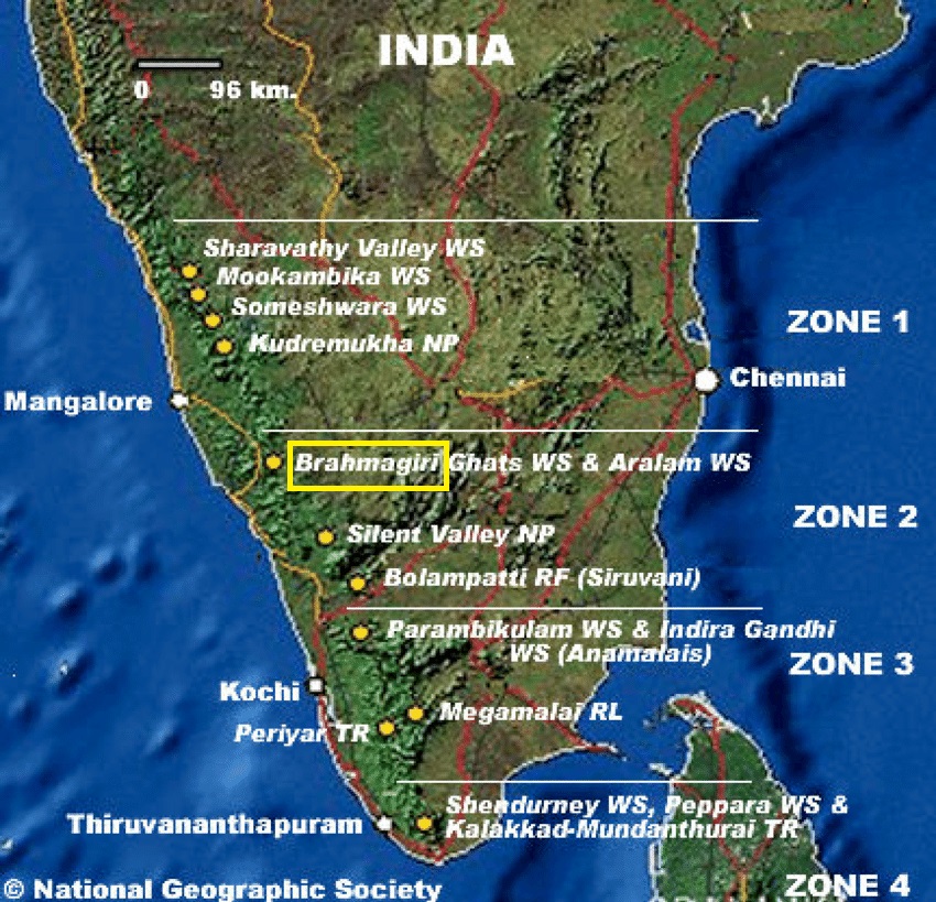
About Brahmagiri Wildlife Sanctuary:
- The Brahmagiri WLS is located in Kodagu District, Karnataka, within the Western Ghats.
- It serves as a crucial ecological corridor, facilitating wildlife movement between Nagarhole National Park and Wayanad Wildlife Sanctuary.
- Geographical Location and Features
-
- It is situated approximately 250 km from Bengaluru and derives its name from the Brahmagiri Peak, the highest point in the region.
- The sanctuary was declared a protected area on June 5, 1974, to conserve its unique flora and fauna.
- The terrain consists of evergreen and semi-evergreen forests, grasslands, and shola forests, which provide a habitat for various species.
-
- Bamboo species are widely spread across the region, providing food for herbivores like elephants and deer.
- The diverse vegetation supports a wide range of faunal species by offering food, shelter, and nesting sites.
-
- Carnivores: Tigers, jungle cats, leopard cats, wild dogs, and sloth bears.
- Herbivores: Indian elephants, gaurs, sambars, spotted deer, barking deer, mouse deer, and wild pigs.
- Primates: Lion-tailed macaques, Nilgiri langurs, slender loris, bonnet macaques, and common langurs.
- Small Mammals & Rodents: Malabar giant squirrels, giant flying squirrels, Nilgiri martens, common otters, brown mongooses, civets, porcupines, and pangolins.
- Reptiles: King cobras, Indian cobras, pythons, Malabar pit vipers.
- Birds: Emerald doves, square-tailed bulbuls, and Malabar trogons.
PYQ:
[2020] Which one of the following protected areas is well-known for the conservation of a sub-species of the Indian swamp deer (Barasingha) that thrives well on hard ground and is exclusively graminivorous?
(a) Kanha National Park
(b) Manas National Park
(c) Mudumalai Wildlife Sanctuary
(d) Tal Chhapar Wildlife Sanctuary |
Get an IAS/IPS ranker as your 1: 1 personal mentor for UPSC 2024
Attend Now
Note4Students
From UPSC perspective, the following things are important :
Prelims level: Darien Gap
Why in the News?
The illegal journey into the US often involves dangerous crossings through multiple countries, including the treacherous Darien Gap – a vast, roadless jungle that connects Colombia and Panama.

What is the Darien Gap?
- The Darien Gap is a 97-km stretch of dense rainforest, swamps, and mountains that forms the only break in the Pan-American Highway, which otherwise runs from Alaska to Argentina.
- Due to its extreme terrain, harsh climate, and lack of infrastructure, the region has remained largely impenetrable.
- However, in recent years, it has become a major migration route, as thousands of people attempt to cross it in hopes of reaching North America.
- Geographical Features:
- Location: Forms the border between Panama and Colombia.
- Terrain: Consists of steep mountains, muddy swamps, fast-flowing rivers, and dense rainforests, making travel extremely difficult.
- Climate: Has a hot, humid, and rainy environment with limited access to food and water.
Geo-Political Significance:
- Migration Crisis: Over 520,000 migrants crossed in 2023, with over 300,000 crossings in early 2024.
- ‘Donkey Route’: Many migrants, including Indians, Venezuelans, Haitians, and Pakistanis, travel through Central American nations like Panama, Costa Rica, and Guatemala before reaching Mexico.
- Criminal Activity: The region is controlled by smuggling networks, drug cartels, and armed groups, who demand money, rob migrants, or subject them to violence.
- Humanitarian Concerns: Reports of sexual assaults, deaths, and disappearances are increasing, with overcrowded shelters and severe shortages of food, water, and medical aid.
PYQ:
[2015] The area known as ‘Golan Heights’ sometimes appears in the news in the context of the events is related to:
(a) Central Asia
(b) Middle East
(c) South-East Asia
(d) Central Africa |
Get an IAS/IPS ranker as your 1: 1 personal mentor for UPSC 2024
Attend Now
Note4Students
From UPSC perspective, the following things are important :
Prelims level: Hollongapar Gibbon WLS
Why in the News?
Exploratory drilling for oil and gas has been approved within the eco-sensitive zone surrounding the Hollongapar Gibbon Wildlife Sanctuary.
About the Hollongapar Gibbon WLS
- Hollongapar Gibbon Wildlife Sanctuary was initially established as Hollongapar Reserve Forest in 1997 and renamed in 2004.
- It is the only habitat for hollock gibbons in India.
- Located in Assam, with the Bhogdoi River along its northern boundary.
- Biome classified as plains alluvial semi-evergreen forests with patches of wet evergreen forests.
- Flora:
- Upper canopy: Dominated by Hollong trees (Dipterocarpus macrocarpus), Sam, Amari, Sopas, Bhelu, Udal, and Hingori.
- Middle canopy: Features Nahar trees.
- Lower canopy: Composed of evergreen shrubs and herbs.
- Fauna:
- Primates: Includes Hoolock Gibbons, Bengal Slow Loris (only nocturnal primate in Northeast India), stump-tailed macaques, northern pig-tailed macaques, eastern Assamese macaques, rhesus macaques, and capped langurs.
- Other mammals: Indian elephants, tigers, leopards, jungle cats, wild boars, civets, squirrels, and more.
About the Hoolock Gibbons:
- Gibbons are the smallest and fastest apes, and they inhabit tropical and subtropical forests across Southeast Asia.
- It is the only ape specie found in India.
- They possess high intelligence, exhibit distinct personalities, and have strong familial bonds, reflecting characteristics similar to other ape species.
- The current population of hoolock gibbons is estimated at around 12,000, found primarily in Northeast India, Bangladesh, Myanmar, and southern China.
- Two distinct species, the eastern hoolock gibbon (Hoolock leuconedys) and the western hoolock gibbon (Hoolock hoolock), were previously reported in India.
- Conservation Status
- IUCN Red List: the western hoolock gibbon is classified as Endangered, and the eastern hoolock gibbon is classified as Vulnerable.
- Both gibbon species in India are placed under Schedule I of the Wildlife (Protection) Act, 1972.
|
PYQ:
[2010] Consider the following pairs:
Protected Area:: Well-known for
1. Bhitarkanika, Orissa :: Salt Water Crocodile
2. Desert National Park, Rajasthan :: Great Indian Bustard
3. Eravikulam, Kerala :: Hoolock Gibbon
Which of the pairs given above is/are correctly matched?
(a) 1 only
(b) 1 and 2 only
(c) 2 only
(d) 1, 2 and 3 |
Get an IAS/IPS ranker as your 1: 1 personal mentor for UPSC 2024
Attend Now
Note4Students
From UPSC perspective, the following things are important :
Prelims level: Inland Mangrove of Guneri
Why in the News?
The Gujarat government has declared the Guneri Inland Mangrove in Kutch as the state’s first Biodiversity Heritage Site (BHS) under The Biological Diversity Act, 2002.

Quick Facts about Mangroves in India:
- “Red List of Mangrove Ecosystems” report released on May 22 (International Day for Biodiversity), 2024.
- India holds 3% of South Asia’s total mangrove cover.
- Mangrove cover increased by 54 sq km (1.10%), reaching 4,975 sq km (0.15% of India’s total area).
- West Bengal leads (42.45%), followed by Gujarat (23.66%) and Andaman & Nicobar Islands (12.39%).
- South 24 Parganas, West Bengal, alone contributes 41.85% of India’s mangrove cover, including Sundarbans National Park.
- Gujarat recorded the highest increase, adding 37 sq km of mangrove cover.
|
About Guneri Inland Mangroves:
- Guneri Inland Mangroves (32.78 hectares) are a rare and unique mangrove ecosystem located in Kutch district, Gujarat.
- It is India’s last remaining inland mangrove site and one of only eight such sites globally.
- Unlike coastal mangroves, which thrive in tidal zones, Guneri mangroves exist inland without direct seawater contact.
- These mangroves have historical and ecological significance, possibly originating after the Miocene marine transgression or forming along the banks of the ancient Saraswati River in the Great Rann of Kutch.
Geographical Features:
- It is located about 45 km from the Arabian Sea and 4 km from Kori Creek.
- Terrain:
- Flat land, unlike coastal mangroves that grow in muddy, tidal zones.
- Devoid of sludge, making it resemble a forest rather than a typical mangrove swamp.
- Water Source:
- Thrives on limestone deposits, which help retain groundwater to sustain the mangroves.
- No direct tidal water influx, relying entirely on underground water connectivity.
- Biodiversity:
- Home to 20 migratory bird species and 25 resident migratory avifaunal species.
- Functions as a vital habitat for local and seasonal wildlife.
PYQ:
[2015] Which one of the following regions of India has a combination of mangrove forest, evergreen forest and deciduous forest?
(a) North Coastal Andhra Pradesh
(b) South-West Bengal
(c) Southern Saurashtra
(d) Andaman and Nicobar Islands |
Get an IAS/IPS ranker as your 1: 1 personal mentor for UPSC 2024
Attend Now
Note4Students
From UPSC perspective, the following things are important :
Prelims level: Ramsar Wetland sites in India
Why in the News?
Ahead of World Wetlands Day (February 2nd), the Environment Ministry announced the inclusion of four new Ramsar sites, bringing India’s total to 89.
The newly designated sites are Sakkarakottai Bird Sanctuary and Therthangal Bird Sanctuary in Tamil Nadu, Khecheopalri Wetland in Sikkim, and Udhwa Lake Bird Sanctuary in Jharkhand. With this, Tamil Nadu now has 20 Ramsar sites, the highest in the country, followed by Uttar Pradesh with 10 sites.
About the Newly Added Ramsar Sites:
|
Description |
| Sakkarakottai Bird Sanctuary, Tamil Nadu |
- Location: Ramanathapuram District, Tamil Nadu.
- Originally an irrigation tank, now a designated bird sanctuary.
- Recharged by northeast monsoon (Oct-Jan).
- Supports 42+ bird species, including Spot-billed Pelican, Grey Heron, Little Cormorant, and Black Kite.
|
| Therthangal Bird Sanctuary, Tamil Nadu |
- Location: Theerthangal Village, Ramanathapuram District, Tamil Nadu.
- A freshwater ecosystem and an important breeding ground for waterbirds.
- Recorded 96 bird species across 18 orders and 44 families.
- Notable species include Oriental Darter, Black-headed Ibis, Asian Woolly-necked Stork, and Spot-billed Pelican.
|
| Khecheopalri Wetland, Sikkim |
- Location: West Sikkim, near Khecheopalri Village.
- A sacred lake revered by Buddhists and Hindus.
- Part of a temperate Himalayan peatland ecosystem, surrounded by broad-leaved mixed temperate forests.
- Flora: Rich in macrophytes, phytoplankton, and zooplankton.
- Fauna: Supports fish species like Cyprinus carpio, Danio aequipinnatus, and various migratory birds (Common Merganser, Tufted Duck).
|
| Udhwa Lake Bird Sanctuary, Jharkhand |
- Location: Sahebganj District, Jharkhand.
- Comprises two interconnected lakes: Pataura (155 ha) and Berhale (410 ha).
- Connected to the Ganga River via the Udhuwa Nala (25 km stretch).
- Pataura Lake depth: ~2 meters; Berhale Lake depth: ~70 cm, covered with aquatic vegetation.
- Flora: Home to 42 algae species and 36 aquatic macrophytes.
- Fauna: Habitat for 83 bird species, including the Near Threatened Black-necked Stork and 22 commercially valuable fish species.
|
PYQ:
[2019] Consider the following statements:
- Under Ramsar Convention, it is mandatory on the part of the Government of India to protect and conserve all the wetlands in the territory of India.
- The Wetlands (Conservation and Management) Rules, 2010 were framed by the Government of India based on the recommendations of Ramsar Convention.
- The Wetlands (Conservation and Management) Rules, 2010 also encompass the drainage area or catchment regions of the wetlands as determined by the authority.
Which of the statements given above is/are correct?
(a) 1 and 2 only
(b) 2 and 3 only
(c) 3 only
(d) 1, 3 and 3 |
Get an IAS/IPS ranker as your 1: 1 personal mentor for UPSC 2024
Attend Now
Note4Students
From UPSC perspective, the following things are important :
Prelims level: Kurdistan Region
Why in the News?
India has dispatched a humanitarian aid consignment to the Kurdistan region of Iraq.

What is the Kurdistan Region?
- The Kurdistan Region refers to areas inhabited by ethnic Kurds, primarily in Iraq, Iran, Syria, and Turkey.
- The Kurdistan Regional Government (KRG) administers Iraqi Kurdistan, an autonomous region in northern Iraq.
- The Kurds, a distinct ethnic and linguistic group, have long sought independence and greater autonomy.
- Geographical Significance:
- Spans across Turkey, Iraq, Iran, and Syria, covering the Zagros Mountains and fertile plains.
- Rich in oil and natural gas, particularly in Iraqi Kurdistan, making it geopolitically significant.
- Controls key border regions and trade routes, influencing regional stability.
- Political Implications:
- The Kurdish struggle for autonomy has led to tensions with central governments, particularly in Iraq and Turkey.
- Kurdish forces (Peshmerga) have played a key role in fighting ISIS and maintaining security in northern Iraq.
- The KRG has diplomatic ties with Western countries but lacks full sovereignty.
Ongoing Dispute:
- The Kurdish independence movement faces opposition from Iraq, Turkey, Iran, and Syria, fearing territorial fragmentation.
- Iraq rejected the 2017 Kurdistan independence referendum, leading to military and economic retaliation.
- Turkey continues military operations against Kurdish groups, considering them a security threat.
- The Turkey-ISIS-Kurd relationship remains controversial, with allegations that Turkey indirectly enabled ISIS against the Kurds.
|
PYQ:
[2018] The term “two-state solution” is sometimes mentioned in the news in the context of the affairs of:
(a) China
(b) Israel
(c) Iraq
(d) Yemen |
Get an IAS/IPS ranker as your 1: 1 personal mentor for UPSC 2024
Attend Now
Note4Students
From UPSC perspective, the following things are important :
Prelims level: Darfur Region
Why in the News?
At least 70 people were killed in a drone strike on the last working hospital in Sudan’s North Darfur capital.

About the Darfur Region
| Details |
- Conflict-prone region in western Sudan, affected by ethnic violence and resource conflicts since 2003.
- Site of one of the world’s worst humanitarian crises, with mass killings and displacement.
- Home to multiple ethnic groups, with tensions between Arab pastoralists and non-Arab farming communities.
- Janjaweed militias, backed by the Sudanese government, accused of genocide and mass atrocities.
- Rapid Support Forces (RSF), formerly Janjaweed, play a key role in ongoing instability.
- Renewed violence in 2023, worsening the humanitarian situation.
|
| Geographical Location |
- Located in western Sudan, bordering Chad, Libya, and the Central African Republic.
- Covers an area of about 493,180 sq. km, nearly the size of France.
- Predominantly arid and semi-arid, with desert in the north and more fertile land in the south.
- Climate-driven water and grazing conflicts, worsened by desertification and climate change.
- Composed of five states: North, South, West, Central, and East Darfur.
- El Fasher is the capital and largest city, serving as an administrative and humanitarian hub.
|
Impact of Conflict
|
- Politically marginalized for decades, leading to armed uprisings against Sudan’s government.
- Conflict escalated in 2003 with rebel groups like the Sudan Liberation Movement (SLM) and Justice and Equality Movement (JEM) demanding greater autonomy.
- Remains a stronghold of rebel activity, contributing to Sudan’s broader instability.
- Ongoing violence impacts regional security, affecting neighboring countries like Chad and the Central African Republic.
|
PYQ:
[2024] Consider the following statements :
Statement-I: There is instability and worsening security situation in the Sahel region.
Statement-II: There have been military takeovers/coups d’état in several countries of the Sahel region in the recent past.
Which one of the following is correct in respect of the above statement?
a) Both Statement-I and Statement-II are correct and Statement-II explains Statement-I
b) Bothe Statement-I and Statement-II are correct, but Statement-II does not explain Statement-I
c) Statement-I is correct, but Statement-II is incorrect
d) Statement-I is incorrect, but Statement-II is correct |
Get an IAS/IPS ranker as your 1: 1 personal mentor for UPSC 2024
Attend Now
Note4Students
From UPSC perspective, the following things are important :
Prelims level: Lao PDR
Why in the News?
The Indian Embassy in Lao PDR has successfully rescued 67 Indian nationals who were trafficked and forced to work in cyber scam centres in the Golden Triangle Special Economic Zone (GTSEZ).

Golden Triangle Special Economic Zone (GTSEZ)
- It is a semi-autonomous economic zone located in Bokeo Province, Lao PDR (Laos), near the borders of Thailand and Myanmar.
- It is situated within the infamous Golden Triangle region, historically known for opium production and drug trafficking.
- It was established to promote tourism, trade, and investment but has been widely criticized for illegal activities, including human trafficking, cyber fraud, and illicit gambling.
|
About Lao PDR (Laos)
| Details |
- Officially known as the Lao People’s Democratic Republic (Lao PDR).
- Gained independence from France in 1953.
- Experienced a civil war (1959–1975), leading to the communist Pathet Lao taking control and abolishing the monarchy in 1975.
- One-party communist state under the Lao People’s Revolutionary Party (LPRP).
- Economic growth driven by hydropower, mining, and agriculture, but remains one of ASEAN’s least developed nations.
- 2023 economic distress due to high debt and inflation, linked to China-backed infrastructure projects like the China-Laos Railway.
|
| Geographical Location |
- Landlocked country in Southeast Asia, bordered by China (north), Vietnam (east), Cambodia (south), Thailand (west), and Myanmar (northwest).
- Capital city: Vientiane, located along the Mekong River near Thailand.
- Total area: 236,800 sq. km, with a mountainous landscape and dense forests.
- The Mekong River flows through Laos, supporting trade, agriculture, and hydropower projects.
- Tropical monsoon climate with a wet season (May-Oct) and a dry season (Nov-Apr).
|
| Political Aspects |
- One-party communist state, ruled by the Lao People’s Revolutionary Party (LPRP) since 1975.
- The most heavily bombed country per capita in history due to the US Secret War (1964–1973).
- Acts as a buffer state between China, Vietnam, and Thailand, playing a role in Mekong River trade and energy exports.
- ASEAN Membership: Joined ASEAN in 1997, contributing to regional diplomacy and economic cooperation.
Challenges:
- Major recipient of Chinese investment under the Belt and Road Initiative (BRI), with concerns over debt sustainability.
|
Get an IAS/IPS ranker as your 1: 1 personal mentor for UPSC 2024
Attend Now
Note4Students
From UPSC perspective, the following things are important :
Prelims level: Nahargarh WLS
Why in the News?
The Forest Department of Rajasthan has initiated efforts to revise the boundaries of the Nahargarh Wildlife Sanctuary to address existing legal and administrative complications.

About the Nahargarh Wildlife Sanctuary
- It was established in 1980, Nahargarh Wildlife Sanctuary is located in Jaipur, Rajasthan.
- It is named after the nearby Nahargarh Fort, which overlooks the sanctuary.
- It is a significant part of the Ranthambore Tiger Reserve corridor, providing a habitat for wildlife movement.
- Geographical Features:
- It is situated in the Aravalli hills, close to Jaipur city, offering a natural escape amidst urban surroundings.
- Its area spans approximately 50 square kilometres, featuring rugged terrain with hills, valleys, and plateaus.
- It has seasonal streams and waterholes that serve as vital water sources for wildlife.
- Flora and Fauna:
- Flora: Comprises dry deciduous and thorny scrub forests, typical of the Aravalli range; Key tree species include Dhok, Babool, Khejri, and Ber; Grassy patches and scattered shrubs provide a diverse ecosystem for herbivores.
- Fauna: Fauna: Includes leopards, hyenas, wild boars, jackals, sambars, chitals, peacocks, partridges, migratory birds, monitor lizards, snakes, turtles, and various pollinators.
PYQ:
[2012] In which one among the following categories of protected areas in India are local people not allowed to collect and use the biomass?
(a) Biosphere Reserves
(b) National Parks
(c) Wetlands declared under Ramsar Convention
(d) Wildlife Sanctuaries |
Get an IAS/IPS ranker as your 1: 1 personal mentor for UPSC 2024
Attend Now
Note4Students
From UPSC perspective, the following things are important :
Prelims level: Chincholi Wildlife Sanctuary
Why in the News?
The Kalaburagi Forest Division is working to relocate a hamlet within the Chincholi Wildlife Sanctuary on the Karnataka-Telangana border to a safer area.
About the Chincholi Wildlife Sanctuary
| Details |
- Declared a wildlife sanctuary in 2011, covering 134.88 sq. km.
- Recognized as the first dryland Wildlife Sanctuary in South India.
- Located in the Kalaburagi District, renowned for its floristic diversity.
- Contributes to the conservation of dryland ecosystems.
|
| Geographical Location |
- Situated in the Hyderabad Karnataka region.
- Features the Chandrampalli Dam and four smaller dams within the sanctuary.
|
| Flora and Fauna |
- Flora: Rich in medicinal plants and tree species like Red Sanders, Sandalwood, Acacia, and Teak.
- Fauna:
- Mammals: Blackbuck, Common Fox, Four-horned Antelope, Indian Wolf, Hyena, and Fruit Bat.
- Birds: Over 35 species, including Black Drongo, Black-winged Kite, Blossom-headed Parakeet, Blue Pigeon, Black-headed Oriole, and Grey Partridge.
|
| Climatic/Geographical Features |
- Comprises dry deciduous and moist deciduous forests.
- Fringes are planted with Acacia and Teak.
- Supports a dryland ecosystem with water bodies like the Chandrampalli Dam.
- Features a mix of arid and semi-moist climatic conditions.
|
PYQ:
[2018] In which one of the following States is Pakhui Wildlife Sanctuary located?
(a) Arunachal Pradesh
(b) Manipur
(c) Meghalaya
(d) Nagaland |
Get an IAS/IPS ranker as your 1: 1 personal mentor for UPSC 2024
Attend Now
Note4Students
From UPSC perspective, the following things are important :
Prelims level: Konark Wheels, Sun Temple, Kalinga Architecture
Why in the News?
The Ministry of Mines, in collaboration with the Government of Odisha, has set up the DMF (District Mineral Foundation) Exhibition at the iconic Sun Temple, Konark.

About the Sun Temple
- It is located approximately 64 km from Bhubaneswar, Odisha.
- It was built in the 13th century (around 1250 CE) during the reign of King Narasimhadeva I of the Eastern Ganga Dynasty.
- It is dedicated to Surya, the Sun God.
- It is designed as a massive chariot drawn by 7 horses with 24 intricately carved wheels.
- It was constructed from Khondalite stone, known for its durability and intricate carvings.
- The structure originally included a sanctum (deul) and an assembly hall (jagamohan) that have largely collapsed.
Historical Significance:
- The Konark Wheel, featured on Indian currency (old ₹20 and new ₹10 notes), symbolizes Odisha’s rich cultural heritage and national identity.
- It reflects 13th-century advancements in timekeeping and astronomy through its sundial functionality.
- It embodies the cycle of life and serves as a testament to the worship of Surya, the Sun God.
- It is a key example of the Kalinga architectural style, highlighting the Eastern Ganga Dynasty’s achievements.

Architectural Significance:
- Design: Represents a chariot of the Sun God, drawn by 7 horses, with 24 intricately carved wheels.
- Wheel Details:
- Diameter: 9 feet 9 inches.
- Spokes: 8 wide and 8 thin, symbolizing prahars (three-hour periods).
- Symbolism:
- 7 horses: 7 days of the week.
- 12 pairs of wheels: 12 months.
- 24 wheels: 24 hours in a day.
- Sundial Functionality: Two wheels act as sundials, showing time from sunrise to sunset using the axel’s shadow.
- Carvings: Features intricate designs of foliage, animals, and human figures, showcasing exceptional craftsmanship.
PYQ:
[2012] The Nagara, the Dravida and the Vesara are the:
(a) Three main racial groups of the Indian subcontinent
(b) Three main linguistic divisions into which the languages of India can be classified
(c) Three main styles of Indian temple architecture
(d) Three main musical Gharanas prevalent in India |
Get an IAS/IPS ranker as your 1: 1 personal mentor for UPSC 2024
Attend Now
Note4Students
From UPSC perspective, the following things are important :
Prelims level: Protected areas mentioned

Why in the News?
A recent faunal survey conducted in the Munnar Wildlife Division has documented 24 new species of birds, butterflies, and odonates, enriching its biodiversity checklist.
Which are the surveyed sites?
All the surveyed national parks and wildlife sanctuaries are located in Kerala, India, specifically in the Idukki district:
- Mathikettan Shola National Park (MSNP): It is a biodiversity hotspot and part of the Western Ghats.
- Pambadum Shola National Park (PSNP): It is Kerala’s smallest national park and home to unique flora and fauna.
- Anamudi Shola National Park (ANP): Named after Anamudi, the highest peak in South India.
- Kurinjimala Wildlife Sanctuary (KWLS): Located in Idukki, it protects the habitat of the Neelakurinji (Strobilanthes kunthiana), a flower that blooms once every 12 years.
- Eravikulam National Park (ENP): Famous for the Nilgiri Tahr.
- Chinnar Wildlife Sanctuary (CWLS): Situated in the rain-shadow region of the Western Ghats, near the Kerala-Tamil Nadu border in Idukki.
|
Key Highlights of the Survey
- New Species Added: 24 new species, including birds (11), butterflies (8), and odonates (5).
- Total Documentation:
- Birds: 217 species recorded; checklist updated to 258.
- Butterflies: 166 species recorded; checklist updated to 246.
- Odonates: 5 new records, checklist updated to 58 species.
- Notable Wildlife Observed: Mammals like Nilgiri Tahr, tigers, leopards, and elephants; 12 species of reptiles and amphibians.
About the Added Species
- Birds:
- New Additions: Brown Hawk Owl, Barred Buttonquail, Spotted Owlet, Mottled Wood Owl, Baya Weaver, Red Munia, Richard’s Pipit, Jerdon’s Bushlark, Golden-Headed Cisticola, Large Grey Babbler, Chestnut-Bellied Nuthatch.
- Highlights: Nilgiri Wood Pigeon, Steppe Eagle, Peregrine Falcon, Indian Grey Hornbill, and Blue-eared Kingfisher.
- Butterflies:
- Endemic Species: Red-disc Bushbrown, Palni Fritillary, Nilgiri Tiger, Nilgiri Four-ring.
- Unique Sightings: Grass Jewel (smallest butterfly in Kerala), Southern Birdwing (largest butterfly in India).
- Odonates (flying insects):
- New Records: Cratilla lineata calverti, Macrodiplax cora, Palpopleura sexmaculata, Tholymis tillarga, Lestes elatus.
PYQ:
[2020] With reference to India’s biodiversity Ceylon frogmouth, Coppersmith barbet, Gray-chinned minivet and White-throated redstart are:
(a) Birds
(b) Primates
(c) Reptiles
(d) Amphibans |
Get an IAS/IPS ranker as your 1: 1 personal mentor for UPSC 2024
Attend Now
Note4Students
From UPSC perspective, the following things are important :
Prelims level: Yala Glacier
Why in the News?
Yala Glacier in Nepal is predicted to disappear by the 2040s due to rapid retreat and mass loss. It is the only glacier in the Himalayas listed on the Global Glacier Casualty List, an initiative launched in 2024 to document endangered or vanished glaciers worldwide.
| Note: The UN has designated 2025 as the International Year of Glacier Preservation, with March 21st to be observed annually as World Glacier Day starting from 2025. |
About the Yala Glacier
- Yala Glacier is located in the Langtang Valley, central Nepal, and is influenced by the Indian summer monsoon.
- It is one of the most studied glaciers in Nepal and represents the Hindu Kush Himalayan region in the World Glacier Monitoring Service (WGMS) database.
- The glacier has been monitored for over a decade using stakes, snow pits, and satellite images, providing crucial data on the state of Himalayan glaciers.
- It is the only glacier in the Himalayas included in the Global Glacier Casualty List, a recognition of its critical status.
- It plays a vital role in studying the cryosphere, a critical water resource supporting 240 million people in the Himalayan region.
Retreat of Yala Glacier
- Yala Glacier is projected to disappear by the 2040s, reflecting the growing threat to Himalayan glaciers.
- It has retreated by 680 meters between 1974 and 2021, with a 36% reduction in area during this period.
- Its elevation, which ranged between 5,170m and 5,750m in 2011, has significantly declined.
- The glacier has lost so much mass that it no longer meets scientific standards for effective observation.
- The Hindu Kush Himalayan cryosphere is warming twice as fast as the global average, leading to rapid glacial retreat.
About the Global Glacier Casualty List
- It was launched in 2024 by a consortium of institutions including Rice University, World Glacier Monitoring Service (WGMS), World Meteorological Organization (WMO), and UNESCO.
- It documents endangered or vanished glaciers.
- Glaciers Listed: Includes 15 glaciers, such as:
- Pico Humboldt Glacier (Venezuela): Disappeared in 2024.
- Sarenne Glacier (France): Vanished in 2023.
- Dagu Glacier (China): Categorized as “critically endangered,” expected to vanish by 2030.
- Significance:
- Highlights the urgency of glacier preservation, as these ice masses store 70% of global freshwater and influence water security for billions of people worldwide.
- Reinforces the need for global cooperation to address the accelerating loss of glaciers due to climate change
|
PYQ:
[2019] Consider the following Pairs :
Glacier: River
- Bandarpunch : Yamuna
- Bara Shigri : Chenab
- Milam : Mandakini
- Siachen : Nubra
- Zemu : Manas
Which of the following pairs given above are correctly matched?
(a) 1,2 and 4
(b) 1,3 and 4
(c) 2 and 5
(d) 3 and 5 |
Get an IAS/IPS ranker as your 1: 1 personal mentor for UPSC 2024
Attend Now
Note4Students
From UPSC perspective, the following things are important :
Prelims level: Kerch Strait
Why in the News?
Two Russian ships spilled 3,350 tonnes of low-grade fuel into the Kerch Strait in Crimea, posing an environmental threat to the biodiversity hotspot.

About the Kerch Strait
- The Kerch Strait is a narrow, strategically crucial waterway connecting the Black Sea and the Sea of Azov.
- It serves as a natural maritime corridor between the Crimean Peninsula and the Russian mainland.
- It stretches approximately 41 kilometers in length and varying between 4-15 kilometers in width.
- The strait features the Kerch-Yenikalsky canal, a critical maritime passage enabling larger vessels to traverse between the Black and Azov Seas.
- Port facilities at Kavkaz and Kerch serve as essential transportation hubs, facilitating significant cargo and passenger movements.
- Geopolitical Significance
- Since Russia’s annexation of Crimea in 2014, the Kerch Strait has become a focal point of international tension.
- The construction of the Crimean Bridge in 2018 provides a direct land connection between Russian territory and the Crimean Peninsula.
PYQ:
[2008] Which one of the following straits is nearest to the International Date Line?
(a) Malacca Strait
(b) Bering Strait
(c) Strait of Florida
(d) Strait of Gibraltar |
Get an IAS/IPS ranker as your 1: 1 personal mentor for UPSC 2024
Attend Now
Note4Students
From UPSC perspective, the following things are important :
Prelims level: Diego Garcia Island

Why in the news?
Indian fishermen from Tamil Nadu, were detained near Diego Garcia in the British Indian Ocean Territory for crossing the maritime boundary.
About the Diego Garcia Island
- The Diego Garcia Island is a part of the British Indian Ocean Territory (BIOT).
- It is situated in the Indian Ocean, south of the equator.
- It is located approximately 1,796 km south of India and 4,723 km east of Africa.
- It was originally inhabited by the Chagossians (Ilois), descendants of African and Indian laborers brought by French colonists.
- It became a British colony in 1814 following the Napoleonic Wars.
Political Significance:
- It houses a significant US military base, established under a 1966 UK-US agreement.
- It plays a critical role in global military operations, particularly in the Middle East and Asia-Pacific.
- It serves as a base for long-range bombers, intelligence-gathering operations, and logistical support.
- The sovereignty of Diego Garcia is disputed by Mauritius, which claims it as part of its territory.
- In 2019, the International Court of Justice (ICJ) advised the UK to return the Chagos Archipelago, including Diego Garcia, to Mauritius.
- The United Nations General Assembly endorsed this ruling.
Get an IAS/IPS ranker as your 1: 1 personal mentor for UPSC 2024
Attend Now