Note4Students
From UPSC perspective, the following things are important :
Prelims level: Ramsar sites in India
Mains level: Wetland conservation in India
The Lonar Lake in Maharashtra and Sur Sarovar, also known as Keetham lake, in Agra, have been added to the list of recognised Ramsar sites.
Make a note of all freshwater and saltwater lakes in India.
Lonar Lake
- Lonar Lake, also known as Lonar crater, is a notified National Geo-heritage Monument, saline (pH of 10.5), Soda Lake, located at Lonar in Buldhana district, Maharashtra.
- It was created by an asteroid collision with earth impact during the Pleistocene Epoch.
- It is one of the four known, hyper-velocity, impact craters in basaltic rock anywhere on Earth.
- It sits inside the Deccan Plateau—a massive plain of volcanic basalt rock created by eruptions some 65 million years ago.
Sur Sarovar
- It is a scenic lake just outside Agra on the Agra – Delhi highway (NH 2) and a declared bird sanctuary.
- The riverine belt of River Yamuna surrounds the area of Sur-Sarovar.
- It is today home to more than 165 species of migratory and resident birds.
- It is the same place that inspired the famed poet Soordas to compose the “Bhakti Kavya” one of the finest pieces of devotional poetry.
Two amongst many
- India now has 41 wetlands, the highest in South Asia, with two more added to the list of recognised sites of international importance under the treaty of Ramsar Convention.
- Recently, Kabartal in Bihar’s Begusarai district was recognised as a wetland of international importance, the first such wetland in the State, under the Ramsar Convention.
- The Asan Conservation Reserve in Dehradun, the first wetland from Uttarakhand to be recognised by Ramsar convention, was added to the list in October this year.
Back2Basics: Wetlands
- A wetland is a distinct ecosystem that is flooded by water, either permanently or seasonally, where oxygen-free processes prevail.
- The primary factor that distinguishes wetlands from other landforms or water bodies is the characteristic vegetation of aquatic plants, adapted to the unique hydric soil.
- Wetlands provide a wide range of important resources and ecosystem services such as food, water, fibre, groundwater recharge, water purification, flood moderation, erosion control and climate regulation.
What is the Ramsar Convention?
- The Ramsar Convention on Wetlands of International Importance Especially as Waterfowl Habitat is a treaty for the conservation and sustainable use of such sites.
- The convention, signed in 1971 in the Iranian city of Ramsar, is one of the oldest inter-governmental accords for preserving the ecological character of wetlands.
- Also known as the Convention on Wetlands, it aims to develop a global network of wetlands for the conservation of biological diversity and for sustaining human life.
- Over 170 countries are party to the Ramsar Convention and over 2,000 designated sites covering over 20 crore hectares have been recognised under it.
Get an IAS/IPS ranker as your 1: 1 personal mentor for UPSC 2024
Attend Now
Note4Students
From UPSC perspective, the following things are important :
Prelims level: Nagorno-Karabakh region
Mains level: Usual crisis in the middle east and caucasus region

Armenia and Azerbaijan agreed on a deal with Russia to end fierce clashes over Nagorno-Karabakh after a string of Azerbaijani victories in its fight to retake the disputed region.
Ending up the bloodshed
- During the course of the conflict, over 1200 have lost their lives as per the Nagorno-Karabakh authorities, while thousands have been displaced.
- Since the conflict started in September, multiple ceasefire agreements have been signed between the two sides, but none so far have been successful.
- The deal is meant to end the conflict between the two nations.
- Russia’s role in the conflict has been somewhat opaque since it supplies arms to both countries and is in a military alliance with Armenia called the Collective Security Treaty Organisation.
What is the Nagorno-Karabakh region?
- Straddling western Asia and Eastern Europe, Nagorno-Karabakh is internationally recognised as part of Azerbaijan, but most of the region is controlled by Armenian separatists.
- It has been part of Azerbaijan territory since the Soviet era.
- When the Soviet Union began to collapse in the late 1980s, Armenia’s regional parliament voted for the region’s transfer to Armenia; the Soviet authorities turned down the demand.
- Years of clashes followed between Azerbaijan forces and Armenian separatists.
- The violence lasted into the 1990s, leaving tens and thousands dead and displacing hundreds of thousands.
- In 1994, Russia brokered a ceasefire, by which time ethnic Armenians had taken control of the region.
Consider this PYQ:
Q.The area is known as ‘Golan Heights’ sometimes appears in the news in the context of the events related to: (CSP 2015)
a) Central Asia
b) Middle East
c) South-East Asia
d) Central Africa
Who controls it?
- While the area remains in Azerbaijan, it is today governed by separatist Armenians who have declared it a republic called the “Nagorno-Karabakh Autonomous Oblast”.
- While the Armenian government does not recognise Nagorno-Karabakh as independent, it supports the region politically and militarily.
Ethnicity and the conflict
- Ethnic tensions from decades ago have a crucial role in the dispute.
- While the Azeris claim that the disputed region was under their control in known history, Armenians maintain that Karabakh was a part of the Armenian kingdom.
- At present, the disputed region consists of a majority Armenian Christian population, even though it is internationally recognised as a part of Muslim-majority Azerbaijan.
Get an IAS/IPS ranker as your 1: 1 personal mentor for UPSC 2024
Attend Now
Note4Students
From UPSC perspective, the following things are important :
Prelims level: Kartarpur Corridor, Nirguna cult
Mains level: Piligrimage diplomacy between India and Pakisatan
Pakistan has decided to transfer the management of the Kartarpur Sahib Gurudwara from a Sikh body to a separate trust, saying it runs against the religious sentiments of the Sikh community.
Try this PYQ:
Consider the following Bhakti Saints:
- Dadu Dayal
- Guru Nanak
- Tyagaraja
Who among the above was/were preaching when the Lodi dynasty fell and Babur took over?
(a) 1 and 3
(b) 2 only
(c) 2 and 3
(d) 1 and 2
Kartarpur Corridor

- The Kartarpur corridor connects the Darbar Sahib Gurdwara in Narowal district of Pakistan with the Dera Baba Nanak shrine in Gurdaspur district in India’s Punjab province.
- The first guru of Sikhism, Guru Nanak, founded Kartarpur in 1504 AD on the right bank of the Ravi River. The name Kartarpur means “Place of God”.
- The corridor is being built to commemorate 550th birth anniversary celebrations of Guru Nanak Dev, founder of Sikhism on 12th November 2019.
About Guru Nanak
- Guru Nanak Dev (1469-1539) also referred to as Baba Nanak was the founder of Sikhism and is the first of the ten Sikh Gurus.
- He advocated the ‘Nirguna’ form of Bhakti. He rejected sacrifices, ritual baths, image worship, austerities and the scriptures of both Hindus and Muslims.
- He appointed one of his disciples, Angad, to succeed him as the preceptor (guru), and this practice was followed for nearly 200 years.
- The fifth preceptor, Guru Arjan, compiled his hymns along with those of his four successors and also other religious poets, like Baba Farid, Ravidas and Kabir, in the Adi Granth Sahib.
Get an IAS/IPS ranker as your 1: 1 personal mentor for UPSC 2024
Attend Now
Note4Students
From UPSC perspective, the following things are important :
Prelims level: Mansar Lakes, Ramsar Sites
Mains level: Wetland conservation in India
Mansar Lake Development Plan is getting fulfilled after a long wait of 70 years.
Try this PYQ:
Q.With reference to a conservation organization called Wetlands International, which of the following statements is/are correct?
- It is an intergovernmental organization formed by the countries which are signatories to Ramsar Convention.
- It works at the field level to develop and mobilize knowledge, and use the practical experience to advocate for better policies.
Select the correct answer using the code given below:
(a) 1 only
(b) 2 only
(c) Both 1 and 2
(d) Neither 1 nor 2
About Mansar Lake
- Situated at about 37 km from Jammu, Mansar is a lake fringed by forest-covered hills, over a mile in length by half-a-mile in width.
- Surinsar-Mansar Lakes are designated as Ramsar Convention in November 2005.
- With all religions belief and heritage behind the Mansar Lake is also picking up its fame among the tourists with all its flora & fauna.
- The lake has cemented path all around with required illumination, with projected view decks to enjoy flickering of seasonal birds, tortoise and fishes of different species.
- There is a wildlife Sanctuary housing jungle life like Spotted Deer, Nilgai etc. besides other water birds such as Cranes, Ducks etc.
Back2Basics: Ramsar Convention
- The Convention on Wetlands of International Importance (better known as the Ramsar Convention) is an international agreement promoting the conservation and wise use of wetlands.
- It is the only global treaty to focus on a single ecosystem.
- The convention was adopted in the Iranian city of Ramsar in 1971 and came into force in 1975.
- Traditionally viewed as a wasteland or breeding ground of disease, wetlands actually provide freshwater and food and serve as nature’s shock absorber.
- Wetlands, critical for biodiversity, are disappearing rapidly, with recent estimates showing that 64% or more of the world’s wetlands have vanished since 1900.
- Major changes in land use for agriculture and grazing, water diversion for dams and canals and infrastructure development are considered to be some of the main causes of loss and degradation of wetlands.
Get an IAS/IPS ranker as your 1: 1 personal mentor for UPSC 2024
Attend Now
Note4Students
From UPSC perspective, the following things are important :
Prelims level: Taiwan strait
Mains level: Not Much

A U.S. warship sailed through the Taiwan Strait in what the American military described as a “routine” passage on but enraging China, which claims sovereignty over the island and surrounding seas.
Try this PYQ:
Q.Which one of the following can one come across if one travels through the Strait of Malacca?
(a) Bali
(b) Brunei
(c) Java
(d) Singapore
Taiwan Strait
- The Taiwan Strait, also known as the Formosa Strait, is a 180 km wide strait separating Taiwan and mainland China.
- The strait is currently part of the South China Sea and connects to the East China Sea to the north. The narrowest part is 130 km wide.
- The entire strait is on Asia’s continental shelf.
- Historically both the People’s Republic of China (PRC) and Taiwan espoused a One-China Policy that considered the strait part of the exclusive economic zone of a single “China”.
Tap to read more about One China Policy at:
Get an IAS/IPS ranker as your 1: 1 personal mentor for UPSC 2024
Attend Now
Note4Students
From UPSC perspective, the following things are important :
Prelims level: Zojila Pass
Mains level: Road infrastructure in Himalayas
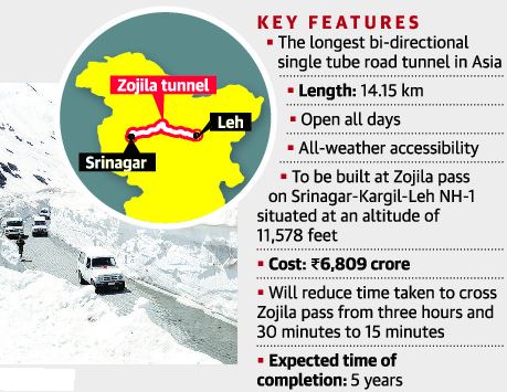
Union Transport Ministry has launched the first blasting for construction-related work at the Zojila tunnel that will provide all-year connectivity between Srinagar valley and Leh.
These days various Himalayan passes and tunnels are overwhelmingly seen in news. Open your Atlas and try to spot all of them for now and once before the exam.
Zojila Tunnel
- The Zojila is set to be Asia’s longest bi-directional tunnel.
- It will connect Srinagar, Dras, Kargil and Leh via a tunnel through the famous Zojila Pass.
- Located at more than 11,500 feet above sea level, the all-weather Zojila tunnel will be 14.15 km long and ensure road connectivity even during winters.
- It will make the travel on the 434-km Srinagar-Kargil-Leh Section of NH-1 free from avalanches, enhance safety and reduce the travel time from more than 3 hours to just 15 minutes.
- The speed limit inside the tunnel is likely to be the same as in the Atal tunnel – 80 kmph.
Its significance
- The project holds strategic significance as Zojila Pass is situated at an altitude of 11,578 feet on the Srinagar-Kargil-Leh National Highway and remains closed during winters due to heavy snowfall.
- At present, it is one of the most dangerous stretches in the world to drive a vehicle and this project is also geo-strategically sensitive.
Get an IAS/IPS ranker as your 1: 1 personal mentor for UPSC 2024
Attend Now
Note4Students
From UPSC perspective, the following things are important :
Prelims level: Kamchatka Peninsula
Mains level: Not Much

An ‘ecological disaster’ of sorts is unfolding on a black volcanic beach of the Kamchatka Peninsula in the Russian Far East, according to a report.
Note the features of the map and surrounding seas.
About Kamchatka Peninsula
- The Kamchatka Peninsula is a 1,250-kilometre-long peninsula in the Russian Far East.
- The Pacific Ocean and the Sea of Okhotsk make up the peninsula’s eastern and western coastlines, respectively.
- Immediately offshore along the Pacific coast of the peninsula runs the 10,500-metre-deep Kuril–Kamchatka Trench.
- The Kamchatka Peninsula, the Commander Islands, and Karaginsky Island constitute the Kamchatka Krai of the Russian Federation.
- The vast majority of the 322,079 inhabitants are ethnic Russians, although about 13,000 are Koryaks (2014).
- The Kamchatka peninsula contains the volcanoes of Kamchatka, a UNESCO World Heritage Site.
Why in news?
- Then, sea animals begin to die in large numbers, their bodies littering the beach.
- These included octopuses, seals, sea urchins, stars, crabs and fish.
- Examination of the seawater by the administration has shown that levels of phenols and oil compounds have spiked.
Get an IAS/IPS ranker as your 1: 1 personal mentor for UPSC 2024
Attend Now