From UPSC perspective, the following things are important :
Prelims level: Heard and McDonald Islands
Why in the News?
Donald Trump imposed a 10% tariff on imports from the Heard and McDonald Islands, despite no human presence there for nearly a decade.
About the Heard and McDonald Islands
The Heard and McDonald Islands are located in the Southern Ocean, approximately 4,100 km south-west of Perth, Australia, and 1,600 km to the north of the Antarctic coast.
The islands are unincorporated external territories of Australia, meaning they are not part of any Australian state but are directly administered by the Australian government.
The islands are home to seals, penguins, and albatrosses, and serve as crucial breeding grounds for these species.
The islands have been designated as UNESCO World Heritage Sites due to their ecological significance, particularly their rich biodiversity.
Heard Island:
Heard Island spans an area of approximately 368 square kilometers.
The island’s highest point is Mawson Peak, an active volcano standing 2,745 meters (9,006 feet) above sea level.
Mawson Peak is one of the most active volcanoes in the southern hemisphere, with eruptions as recent as 2016.
McDonald Islands:
It is much smaller, covering only 2.5 square kilometers.
Geological Nature: These islands are volcanic and part of the same volcanic chain as Heard Island.
Climate
Both islands experience an extremely cold subantarctic climate, with heavy winds, snow, and ice for much of the year.
Temperatures rarely exceed 5°C (41°F) even in summer.
Strategic Significance
The islands are strategically located between Australia and Antarctica, important for monitoring the Southern Ocean, vital for global biodiversity and climate studies.
They play a key role in scientific research, particularly in volcanology, glaciology, and climate change, with Australia operating a research station on Heard Island.
The islands are protected under the Antarctic Treaty System, ensuring no military activity or commercial exploitation in the region.
Rich in marine resources, the surrounding waters are also safeguarded to prevent overfishing and environmental harm.
Their geopolitical importance grows as international competition and territorial claims around Antarctica and the Southern Ocean increase.
From UPSC perspective, the following things are important :
Prelims level: Gulf of Eilat
Why in the News?
Researchers have discovered a significant pause in coral reef growth in the Gulf of Eilat/Aqaba during the late Holocene period.
Key Highlights of the Study:
The study identified a 4,400 – 1,000-year hiatus in coral growth, similar to events observed in Mexico, Brazil, and Australia.
Scientists attribute this temporary halt to a sea-level drop caused by tectonic activity and cooling events, which exposed coral reefs and disrupted their development.
Despite this, the reef recovered by recolonizing from deeper coral communities, showcasing its natural resilience.
About Gulf of Eilat
Also known as the Gulf of Aqaba, it is a narrow extension of the Red Sea, located between the Sinai Peninsula (Egypt) and the Arabian Peninsula.
It connects to the Red Sea through the Strait of Tiran and borders Egypt, Israel, Jordan, and Saudi Arabia.
The city of Eilat (Israel) and Aqaba (Jordan) lie along its shores, making it a strategic trade and tourism hub.
Geographical and Political Significance:
Strategic Trade Route: Provides access to the Indian Ocean via the Red Sea, critical for Israel and Jordan’s maritime trade.
Bordering Multiple Nations: Shares coastlines with Egypt, Israel, Jordan, and Saudi Arabia, making it a key area for regional diplomacy and security.
Tourism & Marine Biodiversity: Known for coral reefs and marine life, attracting divers and boosting the economies of Eilat and Aqaba.
Geopolitical Sensitivity: The Strait of Tiran has been historically significant in Arab-Israeli conflicts, especially during the Six-Day War (1967) when Egypt blocked Israeli access.
Energy & Trade Importance: It is an alternative route for oil shipments and goods trade, reducing reliance on the Suez Canal.
PYQ:
[2014] Which of the following have coral reefs?
1. Andaman and Nicobar Islands
2. Gulf of Kachchh
3. Gulf of Mannar
4. Sunderbans
Select the correct answer using the code given below:
From UPSC perspective, the following things are important :
Prelims level: Darfur Region
Why in the News?
At least 70 people were killed in a drone strike on the last working hospital in Sudan’s North Darfur capital.
About the Darfur Region
Details
Conflict-prone region in western Sudan, affected by ethnic violence and resource conflicts since 2003.
Site of one of the world’s worst humanitarian crises, with mass killings and displacement.
Home to multiple ethnic groups, with tensions between Arab pastoralists and non-Arab farming communities.
Janjaweed militias, backed by the Sudanese government, accused of genocide and mass atrocities.
Rapid Support Forces (RSF), formerly Janjaweed, play a key role in ongoing instability.
Renewed violence in 2023, worsening the humanitarian situation.
Geographical Location
Located in western Sudan, bordering Chad, Libya, and the Central African Republic.
Covers an area of about 493,180 sq. km, nearly the size of France.
Predominantly arid and semi-arid, with desert in the north and more fertile land in the south.
Climate-driven water and grazing conflicts, worsened by desertification and climate change.
Composed of five states: North, South, West, Central, and East Darfur.
El Fasher is the capital and largest city, serving as an administrative and humanitarian hub.
Impact of Conflict
Politically marginalized for decades, leading to armed uprisings against Sudan’s government.
Conflict escalated in 2003 with rebel groups like the Sudan Liberation Movement (SLM) and Justice and Equality Movement (JEM) demanding greater autonomy.
Remains a stronghold of rebel activity, contributing to Sudan’s broader instability.
Ongoing violence impacts regional security, affecting neighboring countries like Chad and the Central African Republic.
PYQ:
[2024] Consider the following statements :
Statement-I: There is instability and worsening security situation in the Sahel region.
Statement-II: There have been military takeovers/coups d’état in several countries of the Sahel region in the recent past.
Which one of the following is correct in respect of the above statement?
a) Both Statement-I and Statement-II are correct and Statement-II explains Statement-I
b) Bothe Statement-I and Statement-II are correct, but Statement-II does not explain Statement-I
c) Statement-I is correct, but Statement-II is incorrect
d) Statement-I is incorrect, but Statement-II is correct
From UPSC perspective, the following things are important :
Prelims level: Lao PDR
Why in the News?
The Indian Embassy in Lao PDR has successfully rescued 67 Indian nationals who were trafficked and forced to work in cyber scam centres in the Golden Triangle Special Economic Zone (GTSEZ).
Golden Triangle Special Economic Zone (GTSEZ)
It is a semi-autonomous economic zone located in Bokeo Province, Lao PDR (Laos), near the borders of Thailand and Myanmar.
It is situated within the infamous Golden Triangle region, historically known for opium production and drug trafficking.
It was established to promote tourism, trade, and investment but has been widely criticized for illegal activities, including human trafficking, cyber fraud, and illicit gambling.
AboutLao PDR (Laos)
Details
Officially known as the Lao People’s Democratic Republic (Lao PDR).
Gained independence from France in 1953.
Experienced a civil war (1959–1975), leading to the communist Pathet Lao taking control and abolishing the monarchy in 1975.
One-party communist state under the Lao People’s Revolutionary Party (LPRP).
Economic growth driven by hydropower, mining, and agriculture, but remains one of ASEAN’s least developed nations.
2023 economic distress due to high debt and inflation, linked to China-backed infrastructure projects like the China-Laos Railway.
Geographical Location
Landlocked country in Southeast Asia, bordered by China (north), Vietnam (east), Cambodia (south), Thailand (west), and Myanmar (northwest).
Capital city:Vientiane, located along the Mekong River near Thailand.
Total area:236,800 sq. km, with a mountainous landscape and dense forests.
The Mekong River flows through Laos, supporting trade, agriculture, and hydropower projects.
Tropical monsoon climate with a wet season (May-Oct) and a dry season (Nov-Apr).
Political Aspects
One-party communist state, ruled by the Lao People’s Revolutionary Party (LPRP) since 1975.
The most heavily bombed country per capita in history due to the US Secret War (1964–1973).
Acts as a buffer state between China, Vietnam, and Thailand, playing a role in Mekong River trade and energy exports.
ASEAN Membership: Joined ASEAN in 1997, contributing to regional diplomacy and economic cooperation.
Challenges:
Major recipient of Chinese investment under the Belt and Road Initiative (BRI), with concerns over debt sustainability.
From UPSC perspective, the following things are important :
Prelims level: Trinidad and Tobago
Why in the News?
The government of Trinidad and Tobago declared a state of emergency on December 30, 2024, in response to escalating violence in the Caribbean nation.
About Trinidad and Tobago
Geography:
Located in the southern Caribbean, near Venezuela.
A dual-island nation consisting of Trinidad (4,768 sq. km) and Tobago (300 sq. km).
Total land area: 5,128 sq. km.
Climate: Tropical, with a dry season from January to May and a rainy season from June to December.
Population:
Approximately 1.5 million people.
Ethnic Composition: African (36.3%), Indian (35.4%), Mixed (22.8%), European, Chinese, and others.
Religions: Christianity (64%), Hinduism (18%), Islam (5%), and others.
Capital and Cities:
Capital: Port of Spain (Trinidad).
Other key cities: San Fernando, Chaguanas, and Scarborough (Tobago).
Political System:
Government Type: Parliamentary democracy under a constitutional republic.
Member of the Commonwealth of Nations.
Gained independence from the UK on August 31, 1962, and became a republic in 1976.
Infrastructure:
Ports: Port of Spain, Point Lisas, and Scarborough are critical for trade.
Airports: Piarco International Airport (Trinidad) and A.N.R. Robinson International Airport (Tobago).
Culture and Heritage:
Known for the Carnival, one of the world’s largest pre-Lenten celebrations.
Birthplace of Calypso music, Soca, and the Steelpan (the only acoustic musical instrument invented in the 20th century).
Geo-Political Significance
T&T is a major exporter of liquefied natural gas (LNG) and petrochemicals (methanol and ammonia), supplying markets in the U.S., Europe, and Latin America.
It is positioned at the crossroads of the Caribbean Sea and Atlantic Ocean, serving as a gateway between North and South America.
It is a founding member of the Caribbean Community (CARICOM) advocating for regional economic integration, disaster response, and collective security.
It is a active member of the Commonwealth and the United Nations, pushing for climate change resilience and sustainable development initiatives.
From UPSC perspective, the following things are important :
Prelims level: Urengoy-Pomary-Uzhgorod pipeline;
Mains level: Geopolitical tension in Europe;
Why in the News?
For over 40 years, Russian gas has been transported to Europe through Ukraine, but these supplies are set to cease on January 1, following Ukraine’s Naftogaz decision not to renew its most recent five-year transit agreement with Russia’s Gazprom.
Note:Student you can use this content in Prelims for facts related to map and mains exam for substantiate the argument related to geopolitical tension in Europe.
Do you know about the Urengoy-Pomary-Uzhgorod pipeline?
The Urengoy-Pomary-Uzhgorod pipeline, also known as the Brotherhood pipeline, is a significant natural gas export route from Russia to Europe, primarily traversing Ukraine. The pipeline starts at the Urengoy gas field in northwest Siberia and extends southwest to Uzhhorod, Ukraine, near the Slovakian border.
It spans approximately 4,500 kilometers (2,800 miles), with about 1,160 kilometers (720 miles) located in Ukraine.
The pipeline was commissioned in 1984 and has been a crucial part of Russia’s gas export strategy to Europe.
What is the volume of gas supplied through Ukraine?
Historical Context: At its peak, the pipeline system, including the Urengoy-Pomary-Uzhgorod pipeline, delivered approximately 201 billion cubic meters (bcm) of gas to Europe in 2018. However, this volume has drastically decreased over the years due to geopolitical tensions and the ongoing conflict in Ukraine.
Recent Figures: In 2023, only about 15 bcm of gas was shipped through Ukraine, a significant drop from 65 bcm when the last five-year contract began in 2020.
What are the Possible Impacts?
Economic Consequences for Ukraine: Ukraine is expected to lose up to $1 billion annually in transit fees due to the cessation of gas flows. To mitigate this loss, it plans to quadruple gas transmission tariffs for domestic consumers, which could burden its industry with additional costs exceeding $38.2 million per year.
Impact on Gazprom: Russia’s Gazprom is projected to lose around $5 billion in gas sales as a result of this halted transit.
European Energy Security: The European Union has prepared for this transition and does not anticipate immediate impacts on consumer prices.
Countries like Slovakia and Austria have secured alternative gas supplies from sources such as Norway and LNG imports from the U.S. and Qatar.
Hungary will continue receiving Russian gas through the TurkStream pipeline under the Black Sea.
TurkStream pipeline
Energy Crisis in Moldova: The cessation has led to an energy emergency in Transdniestria, a breakaway region of Moldova that relies on these transit flows, resulting in cutoffs of heating and hot water supplies for residents
Way forward:
Enhanced Energy Diversification: Europe and Ukraine should continue to strengthen alternative energy supply routes, including LNG imports and renewable energy projects, to reduce reliance on Russian gas and ensure long-term energy security.
Support for Affected Regions: Provide immediate humanitarian and financial assistance to regions like Transdniestria and Moldova for energy infrastructure upgrades, while encouraging energy-efficient solutions to mitigate the crisis.
Mains PYQ:
Q What is the significance of Indo-US defence deals over Indo-Russian defence deals? Discuss with reference to stability in the Indo-Pacific region. (UPSC IAS/2020)
From UPSC perspective, the following things are important :
Prelims level: Nicaragua and its location
Why in the News?
Indian and Nicaragua has signed an umbrella agreement on Quick Impact Projects (QIPs).
The agreement aims at socio-economic development by implementing QIPs in Nicaragua, which will directly benefit local communities.
About Nicaragua: Quick Facts
Nicaragua is located in Central America, bordered by Honduras to the north, Costa Rica to the south, the Pacific Ocean to the west, and the Caribbean Sea to the east.
The capital of Nicaragua is Managua; official language spoken in Nicaragua is Spanish; currency is the Nicaraguan córdoba (NIO).
Nicaragua operates as a unitary presidential republic.
The country’s economy is primarily based on agriculture, including coffee, bananas, and sugar, along with manufacturing and mining.
Geographical Features:
Nicaragua’s topography is predominantly mountainous in the interior, with lowland plains along its Pacific and Caribbean coasts.
The country is home to over 20 volcanoes, with active ones such as Masaya and San Cristóbal.
The largest lake in Nicaragua is Lake Cocibolca, also known as Lake Nicaragua, which is one of the largest lakes in Latin America.
Nicaragua is also known for its significant rivers, including the San Juan River, which flows into the Caribbean Sea, and the Río Coco, the longest river in Central America.
India- Nicaragua Relations:
Diplomatic relations were established in March 1983, and the Indian Embassy in Panama is concurrently accredited to Nicaragua.
Nicaragua’s embassy in India was closed in 1990, and currently, Nicaragua is represented in India through its Embassy in Tokyo.
What are Quick Impact Projects (QIPs)?
QIPs are initiatives designed to deliver rapid and visible benefits to local communities, especially in areas with critical infrastructure and social development needs.
These projects are often implemented in a short time frame.
They are focused on addressing urgent and immediate issues that can have a significant positive impact on the community.
The term is commonly used by organizations like the UNHCR to describe such initiatives in crisis or displacement situations.
Examples of QIPs may include:
Building roads in remote areas to improve connectivity.
Establishing community centers that serve as hubs for local services.
Improving healthcare facilities with basic medical equipment and services.
Upgrading educational infrastructure by building schools or providing learning materials.
From UPSC perspective, the following things are important :
Prelims level: Jordan River and its Valley
Why in the News?
Extremist groups held drone strikes on Israeli territory in the Jordan Valley (which forms Jordan’s border with Israel and the West Bank).
About Jordan Valley:
Details
Geography
• Part of the Great Rift Valley, extending from the Sea of Galilee to the Dead Sea.
• Forms a natural border between Jordan, Israel, and the West Bank.
• Low-lying, with parts below sea level, especially near the Dead Sea.
Climate
• Semi-arid to arid, with hot summers and mild winters.
• Limited rainfall, necessitating irrigation for agriculture.
Significance
• An essential agricultural region, growing citrus, dates, and vegetables.
• The Jordan River is a vital water source for agriculture and drinking water.
• Ecological corridor for migratory birds.
History
• Rich in biblical and historical significance, including Jesus’ baptism in the Jordan River.
• Archaeological sites from ancient civilizations like the Canaanites and Romans.
Geopolitical Aspects
• Critical in the Israeli-Palestinian conflict, with strategic importance for security and border control.
• Vital for Palestinian economic development and a future state.
• Shared water resources create tensions between Israel, Jordan, and Syria.
Economic Activities
• Agriculture is the mainstay of the economy.
• Tourism is also significant due to religious and historical sites.
Environmental Concerns
• Water scarcity and the shrinking Dead Sea due to river diversion are major issues.
• Pollution and overuse of the Jordan River affect water quality and ecosystem health.
PYQ:
[2015] Which one of the following countries of South-West Asia does not open out to the Mediterranean Sea?
From UPSC perspective, the following things are important :
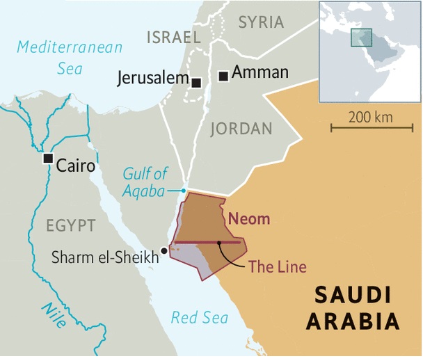
Prelims level: Neom Megacity Project
Why in the News?
The Wall Street Journal has highlighted controversies surrounding the Neom Megacity Project, a key project of Saudi Arabia and world’s largest construction real-estate project.
AboutNeom Megacity Project:
Details
Location
Northwestern Tabuk Province, Saudi Arabia, along the Red Sea
Launched
2017 by Crown Prince Mohammed bin Salman
Part of Saudi Arabia’s Vision 2030.
Objective
To diversify Saudi Arabia’s economy and reduce its reliance on oil.
Size
26,500 sq km
Initially $500 billion, now estimated at $1.5 trillion
Completion Year
Expected by 2039
Key Projects
The Line: 170-km long linear city for 9 million residents
Oxagon: Octagonal industrial city
Trojena: Mountain resort for 2029 Asian Winter Games
Magna: Luxury coastal city
Sindalah: Luxury island, opening in 2024
Technological Focus
Renewable energy (solar, wind)
AI and robotics
Green hydrogen production
Environmental Goals
Powered by 95% renewable energy
Focus on sustainable development
Controversies surrounding the Project:
Displacement of Indigenous Tribes: The Huwaitat tribe has been forcibly displaced, leading to human rights concerns.
Slow Progress: Construction is behind schedule, with only 1.4 km of The Line expected to be completed by 2030.
Workplace Misconduct: Reports of toxic culture and unethical leadership, including neglect of worker safety.
Surveillance Concerns: Critics worry about the project’s use of real-time monitoring, raising privacy concerns.
Cost Overruns: The project’s budget has ballooned from $500 billion to $1.5 trillion, leading to scaled-down plans.
From UPSC perspective, the following things are important :
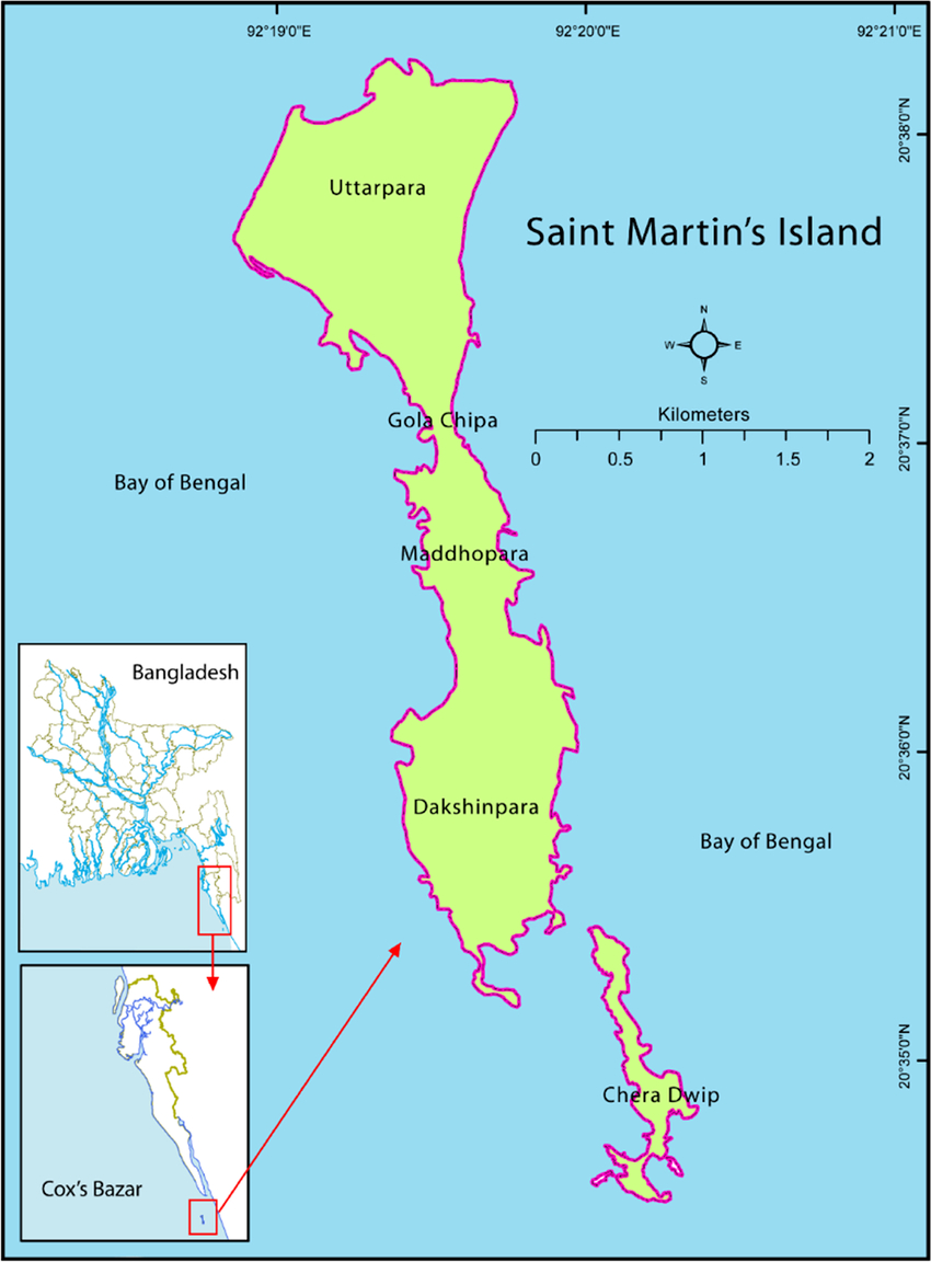
Prelims level: St Martin’s Island
Why in the News?
The ousted Bangladeshi PM Sheikh Hasina claimed she could have stayed in power if she had given up St. Martin’s Island and parts of the Bay of Bengal to the United States.
About St Martin’s Island
St. Martin’s Island is located in the northeastern region of the Bay of Bengal, near the maritime boundary betweenBangladesh and Myanmar.
It lies about 9 kilometerssouth of the Cox’s Bazar-Teknaf peninsula in Bangladesh.
The island is approximately 7.3 km long and is mostly flat, with an elevation of about 3.6 meters above mean sea level.
It is Bangladesh’s only coral island and is surrounded by coral reefs that extend 10-15 km to the west-northwest of the island.
Historical Background:
The island was originally part of the Teknaf peninsula but gradually submerged into the sea around 5,000 years ago.
It resurfaced approximately 450 years ago.
Arab merchants were among the first settlers in the 18th century. They named it “Jazira” and later “Narikel Jinjira” (Coconut Island).
In 1900, British India annexed the island, and it became known as St. Martin’s Island, named after a Deputy Commissioner of Chittagong.
Strategic importance:
Near the Strait of Malacca: Close to one of the world’s busiest maritime routes, making it strategically important for military oversight.It offers potential for monitoring maritime activities, including strategic interests of global powers.
Border with Myanmar: Proximity to Myanmar adds significance in regional security dynamics.
Other significance for Bangladesh:
It is part of Bangladesh’s EEZ, rich in marine resources like fish, oil, and gas. Also a key tourist destination.
It is important for biodiversity, with coral reefs and diverse marine life.
PYQ:
[2023] Consider the following pairs:
Area of conflict mentioned in news: Country where it is located
1.Donbas: Syria
2.Kachin: Ethiopia
3.Tigray: North Yemen
How many of the above pairs are correctly matched?
From UPSC perspective, the following things are important :
Prelims level: Mapping of these locations.
Why in the News?
Details
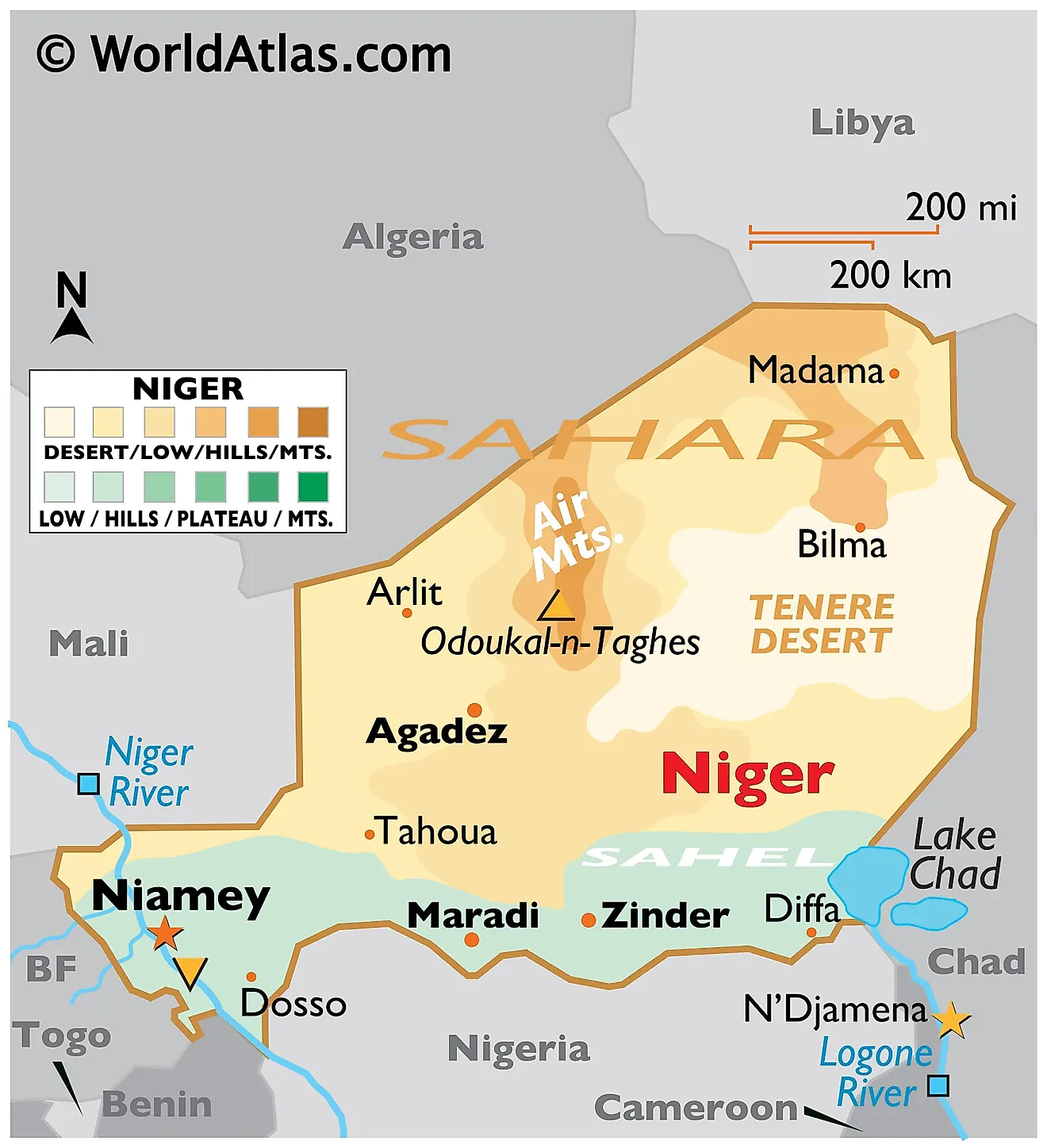
Niger
Turkish delegation visited to strengthen military cooperation with the junta, shifting alliances to Turkey and Russia.
Geography: Landlocked in West Africa, bordered by Algeria, Libya, Chad, Nigeria, Benin, Burkina Faso, and Mali. Population ~26.3 million; capital Niamey.
Key Points:
Gained independence from France in 1960.
Political instability with coups and a military junta in 2023.
It faces significant challenges including desertification, water scarcity, and economic development issues.
It is one of the world’s poorest nations despite having large uranium reserves.
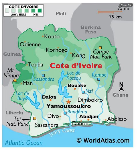
Ivory Coast
Recent discoveries have revealed substantial oil reserves estimated at six billion barrels, potentially making Ivory Coast a net oil exporter by the end of the decade.
The Baleine field, operated by Eni, aims to reach significant production levels by 2026.
Geography: Located on the southern coast of West Africa; bordered by Liberia, Guinea, Mali, Burkina Faso, Ghana, and the Gulf of Guinea. Population ~30.9 million; capital Yamoussoukro.
Key Points:
Gained independence from France in 1960.
Experienced political instability, now relatively stable since 2016.
Fast-growing economy dependent on cocoa, coffee, and expanding into gold mining and oil refining.
Abidjan is a major hub for West African economic activities.
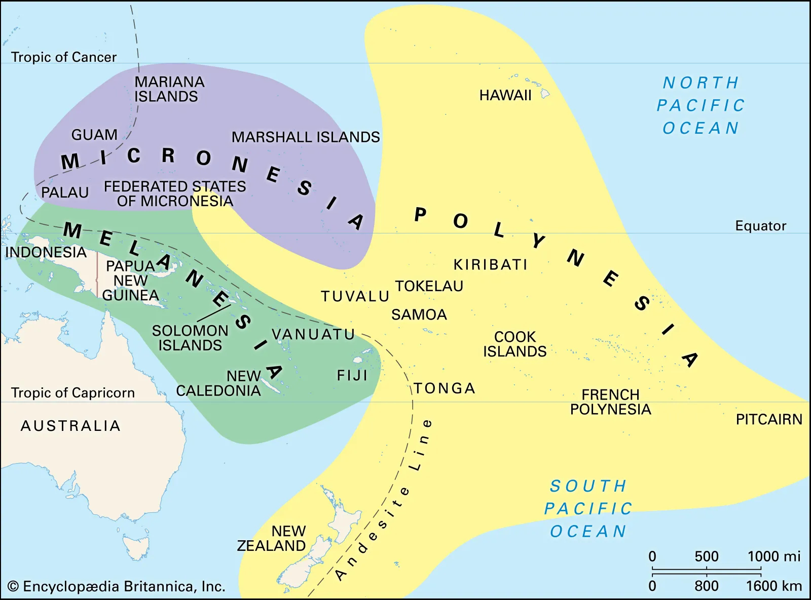
Pacific Island States
Participated in a summit with Japan expressing concerns over military build-ups and the need for regional peace and security.
Geography: Vast region in the Pacific Ocean, categorized into Melanesia, Micronesia, and Polynesia; diverse climates and ecosystems.
They face challenges such as climate change impacts, biodiversity loss, and varying levels of development.
Economic activities include tourism, agriculture (especially coconut and palm oil), and fishing.
These islands play a crucial role in global biodiversity and climate resilience efforts.
PYQ:
[2022] Consider the following pairs:
Region often mentioned in the news: Country
Anatolia: Turkey
Amhara: Ethiopia
Cabo Delgado: Spain
Catalonia: Italy
How many pairs given above are correctly matched?
(a) Only one pair
(b) Only two pairs
(c) Only three pairs
(d) All four pairs
[2018] Consider the following pairs:
Towns sometimes mentioned in news: Country
1. Aleppo: Syria
2. Kirkuk: Yemen
3. Mosul: Palestine
4. Mazar-i-Sharif: Afghanistan
Which of the pairs given above are correctly matched?
From UPSC perspective, the following things are important :
Prelims level: MND and its causes; NIMHANS.
Why in the News?
The annual conference on Motor Neuron Disease (MND) ‘Awareness, Care and Management’ was held at NIMHANS.
What is Motor Neuron Disease (MND)?
MND is a condition that affects the nerves in the brain and spinal cord, which are responsible for controlling your muscles.
Over time, these nerves (called motor neurons) stop working properly, leading to muscle weakness and wasting away.
Types of MND:
Amyotrophic Lateral Sclerosis (ALS): The most common type. It affects both upper and lower motor neurons, leading to weakness in various body parts.
Progressive Bulbar Palsy (PBP): Affects the nerves in the brainstem, leading to problems with speaking and swallowing.
Progressive Muscular Atrophy (PMA): Affects only the lower motor neurons, causing muscle weakness and wasting.
Primary Lateral Sclerosis (PLS): Affects only the upper motor neurons, causing stiffness and movement difficulties.
Causes of MND:
Genetic Factors: In some families, MND can be inherited due to specific gene mutations.
Environmental Factors: Exposure to certain toxins, viruses, or physical injuries might contribute, but this is less clear.
Age and Gender: It usually affects people between the ages of 50 and 70 and is slightly more common in men.
Symptoms:
Muscle Weakness: Starts in one part of the body, like an arm or leg, and gradually spreads.
Muscle Cramps and Twitching: Small, involuntary muscle movements.
Difficulty Speaking and Swallowing: Due to weakness in the muscles used for these functions.
Breathing Problems: In advanced stages, muscles that control breathing can be affected.
Emotional Changes: Some people might experience changes in behavior or thinking.
Diagnosis:
Clinical Examination: A doctor examines your symptoms and medical history.
Electromyography (EMG): Tests the electrical activity of your muscles.
Nerve Conduction Studies (NCS): Checks how well your nerves send signals.
MRI: Scans to rule out other conditions.
Genetic Testing: To check for inherited forms of MND.
Treatment:
There is no cure for MND, but treatments can help manage symptoms and improve quality of life.
Medications:
Riluzole: Can slow down the progression of ALS.
Edaravone: Another drug that may slow down the decline in daily activities.
Symptomatic Treatments: For muscle cramps, excess saliva, and emotional symptoms.
Therapies:
Physical Therapy: Helps maintain muscle strength and mobility.
Occupational Therapy: Aids in performing daily activities.
Speech Therapy: Assists with speech and swallowing difficulties.
Respiratory Therapy: Supports breathing issues.
Back2Basics: National Institute of Mental Health and Neuro-Sciences (NIMHANS)
Details
Location
Bangalore, India
Affiliation
Autonomous institute under the Ministry of Health and Family Welfare, Government of India
Ranking
Ranked 4th best medical institute in India by the “National Institutional Ranking Framework (NIRF)”
History
Founded in 1847 as the Bangalore Lunatic Asylum.
Renamed as the Mental Hospital in 1925.
Amalgamated with the All India Institute of Mental Health (AIIMH) in 1974 to form NIMHANS.
Conferred with deemed university status by the University Grants Commission in 1994.
Declared an Institute of National Importance by an act of parliament in 2012.
Governance
Operates with academic autonomy under the “Societies Registration Act, 1860”.
Prioritises service, manpower development, and research in mental health and neurosciences.
A multidisciplinary integrated approach was adopted for translating research results into practice.
Funding
Receives resources for academic and research activities from national and international funding organisations.
Outreach
Engages in mental health outreach initiatives including critiquing mental health reports and collaborating with government agencies for training and counseling.
Known for diagnosing and treating various mental health conditions including depression and neurobiological disorders.
From UPSC perspective, the following things are important :
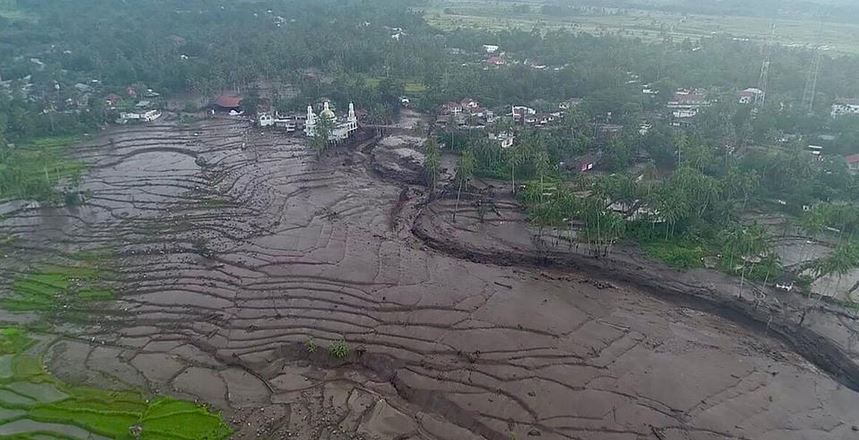
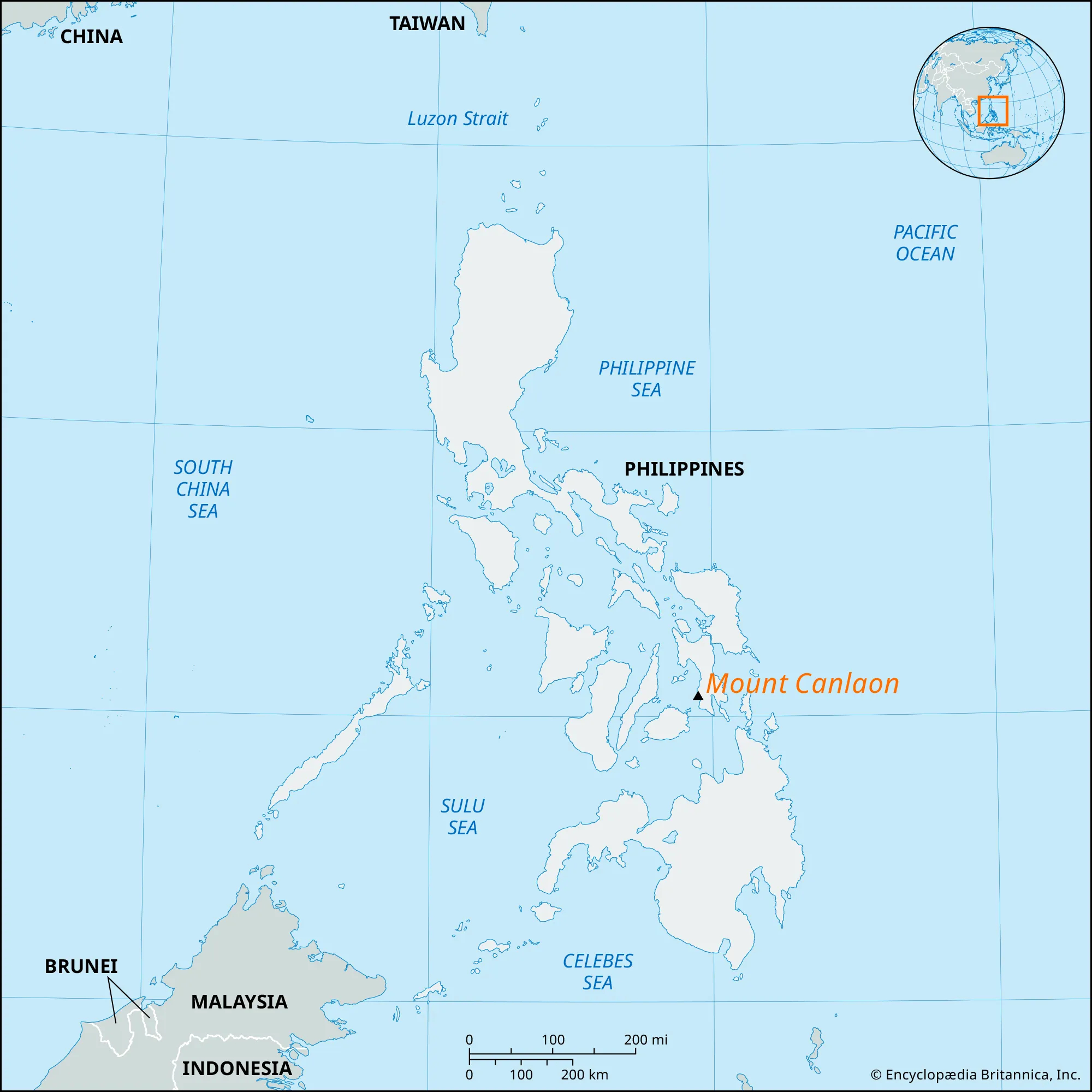
Prelims level: Mount Canlaon, Cold Lava Mudflows
Why in the News?
After Mount Canlaon erupted in the Philippines, cold lava started flowing through streets and rivers.
It was followed by ashfall, and dangers like floods and mudflows downstream.
What is Cold Lava?
Cold lava, also known as “lahar,” is a mixture of water and rock fragments that flows rapidly down the slopes of a volcano, often triggered by heavy rainfall or volcanic eruptions.
The mixture forms a concrete-like substance that destroys everything in its path.
This can also include smooth, glassy textures or rough and jagged textures.
Another example of cold Lava in the world
Mount Merapi, Indonesia (2023): An eruption of Mount Merapi resulted in the deaths of at least 23 climbers and spewed ash up to 3,000 meters into the air, covering towns and villages
How harmful is Cold Lava?
Rain can carry cold lava down the slopes of a volcano during an eruption and into the path of nearby towns or villages.
According to the United States Geological Survey, cold lava has the power to crush and bury things in its path.
It also moves quickly like wet concrete and is considered more destructive than hot lava.
About Mount Canlaon
Mount Canlaon, located in the Philippines, is an active stratovolcano known for its frequent eruptions and volcanic activity.
It is situated on the island of Negros in the Visayas region of the Philippines.
It is part of the Pacific Ring of Fire, known for its high volcanic activity.
It poses hazards such as ash fall, lava flows, pyroclastic flows, and lahars (mudflows) that can endanger nearby communities and agriculture.
PYQ:
[2021] Discuss about the vulnerability of India to earthquake-related hazards. Give examples including the salient features of major disasters caused by earthquakes in different parts of India during the last three decades.
From UPSC perspective, the following things are important :
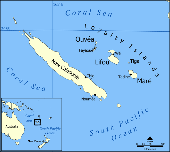
Prelims level: Mapping of New Caledonia
Why in the News?
New Caledonia, France’s Pacific island territory, is under a state of emergency due to deadly riots.
About New Caledonia
New Caledonia is a French overseas territory in the Pacific.
It enjoys a large degree of autonomy but depends heavily on France for matters like defence and education.
It includes the island of New Caledonia where the capital, Noumea, is located, the Loyalty Islands; the Belep Islands; and the Ile des Pins.
New Caledonia’s lagoons were designated a UNESCO World Heritage site in 2008.
The Crisis: A Quick Recap
New Law: The French government passed a law that has upset people in New Caledonia.
Vote Reforms: Now, French citizens who lived on the island for 10 years or more can vote. The government says it’s fairer this way.
Resistance from Indigenous people: The locals, especially the Kanak community, feel this gives too much power to French settlers and stops them from gaining independence.
How did France occupy this territory?
Exploration: British explorer James Cook named the island New Caledonia in 1774 after the Latin name for Scotland.
French Annexation: France annexed it in 1853 and New Caledonia became a French overseas territory in 1946.
Fewer Locals: France brought in lots of French people. Now, the original Kanak people are only 40% of the population, while others, like the Caldoches and newer French arrivals, make up the rest.
Why are the people protesting?
There were similar fights in the 1990s, leading to promises of more power for locals.
In 2018, 2020, and 2021, they voted on whether to be independent from France. But many boycotted the last vote, saying it wasn’t fair because of the pandemic.
Why is it significant for France?
France sees New Caledonia as important for keeping power in the region.
It wants to stay strong in the Pacific to stand up to other big powers, like China.
PYQ:
[2014] Explain how the foundations of the modern world were laid by the American and French revolutions.